|
| Mesoscale Discussion 1174 |
|
< Previous MD Next MD >
|
|
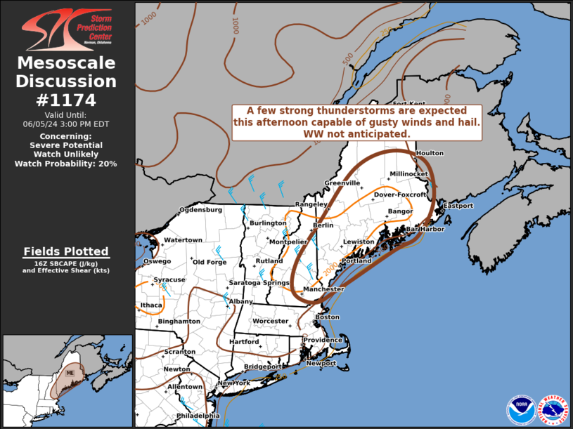
   Mesoscale Discussion 1174
   NWS Storm Prediction Center Norman OK
   1154 AM CDT Wed Jun 05 2024

   Areas affected...Much of Maine and southern New Hampshire

   Concerning...Severe potential...Watch unlikely

   Valid 051654Z - 051900Z

   Probability of Watch Issuance...20 percent

   SUMMARY...Scattered afternoon thunderstorms are expected to develop
   across parts of ME and southern NH.  A few strong/severe storms are
   possible with gusty winds and hail.  A WW is not currently
   anticipated.

   DISCUSSION...Visible satellite imagery shows increasing cu/tcu
   across western ME and southern NH.  This area has warmed into the
   70s and lower 80s, with dewpoints in the mid 60s yielding SBCAPE
   values of 1000-1500 J/kg.  Relatively steep low-level lapse rates
   and sufficiently strong northwesterly flow aloft will aid in the
   development of a few organized cells this afternoon capable of
   locally gusty winds.  Cold temperatures aloft and moderately steep
   mid-level lapse rates may also encourage the risk of hail in the
   strongest cells.  It appears that the overall coverage of
   strong/severe storms will be limited.  Thus, a WW is not currently
   anticipated.

   ..Hart/Smith.. 06/05/2024

   ...Please see www.spc.noaa.gov for graphic product...

   ATTN...WFO...CAR...GYX...BOX...

   LAT...LON   42807103 43037170 43717163 44677089 45906979 46296853
               46016746 45146724 44346776 43996855 43127028 42807103
|
|
Top/All Mesoscale Discussions/Forecast Products/Home
|
|


 @NWSSPC