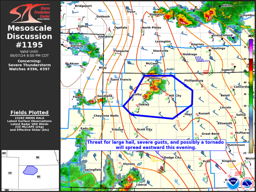
   Mesoscale Discussion 1195
   NWS Storm Prediction Center Norman OK
   0630 PM CDT Fri Jun 07 2024

   Areas affected...Northwest KS

   Concerning...Severe Thunderstorm Watch 396...397...

   Valid 072330Z - 080100Z

   The severe weather threat for Severe Thunderstorm Watch 396, 397
   continues.

   SUMMARY...The threat for large hail, severe gusts, and possibly a
   tornado will spread eastward this evening.

   DISCUSSION...A longer-lived supercell that earlier developed across
   southwest NE is currently moving into northwest KS, with additional
   development noted to its south along a surface confluence zone.
   Moderate to strong buoyancy (MLCAPE of 2000-3000 J/kg) and favorable
   deep-layer shear (with effective shear of around 50 kt) will
   continue to support supercell potential into the early evening as
   convection spreads eastward.

   Large hail (possibly golfball to baseball size) may remain the most
   prominent severe hazard in the short term, given the supercell mode
   and favorable midlevel lapse rates and buoyancy, though isolated
   severe gusts will also be possible. In addition, some increase in
   low-level flow has been noted in the KUEX and KDDC VWP, with backed
   surface winds and some increase in low-level moisture noted
   downstream of the ongoing supercells. This could support a brief
   tornado threat as well.

   With the ongoing increase in storm coverage and some continued
   strengthening of the low-level jet expected this evening, some
   upscale growth of this storm cluster will be possible with time,
   which would potentially be accompanied by an increasing severe-wind
   threat.

   ..Dean.. 06/07/2024

   ...Please see www.spc.noaa.gov for graphic product...

   ATTN...WFO...GID...DDC...GLD...

   LAT...LON   39930065 39949970 39559902 39189904 38819969 38910107
               39130135 39450099 39590091 39930065
|


 @NWSSPC