|
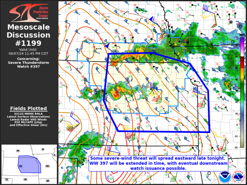
| Mesoscale Discussion 1199 |
|
< Previous MD Next MD >
|

|
   Mesoscale Discussion 1199
   NWS Storm Prediction Center Norman OK
   1014 PM CDT Fri Jun 07 2024

   Areas affected...Central/eastern KS...extreme southeast NE...western
   MO

   Concerning...Severe Thunderstorm Watch 397...

   Valid 080314Z - 080445Z

   The severe weather threat for Severe Thunderstorm Watch 397
   continues.

   SUMMARY...Some severe-wind threat may continue into the overnight
   hours. WW 397 will be extended in time, with eventual downstream
   watch issuance possible.

   DISCUSSION...One long-lived storm cluster is currently moving out of
   south-central/southeast NE into northern KS, with another small but
   intense storm cluster moving eastward across central KS. The central
   KS cluster recently produced a 70 kt gust in Russell, and will
   continue to pose a threat for 65-80 mph gusts (along with isolated
   hail) as it moves through an environment with MLCAPE of greater than
   2500 J/kg and strong effective shear. A threat for at least isolated
   hail and severe gusts will also accompany the northern cluster in
   the short term as it moves southeastward into a larger portion of
   northern KS.

   Storm evolution later tonight remains uncertain. A strong low-level
   jet will continue to support organized convection into the overnight
   hours. However, uncertainty remains regarding the potential
   interaction between the northern and southern cluster, and any
   potential for further upscale growth with time. With some severe
   threat likely to persist into at least the early overnight hours, WW
   397 will be extended in time by 2 hours (until 1 AM CDT). Eventual
   downstream watch issuance remains possible, if trends support a
   continued organized severe risk into the overnight hours.

   ..Dean/Bunting.. 06/08/2024

   ...Please see www.spc.noaa.gov for graphic product...

   ATTN...WFO...SGF...EAX...OAX...TOP...ICT...GID...DDC...

   LAT...LON   38619891 40289873 40349671 39959492 38979412 37469411
               37529822 38229869 38619891
|
|
Top/All Mesoscale Discussions/Forecast Products/Home
|
|


