|
| Mesoscale Discussion 1202 |
|
< Previous MD Next MD >
|
|
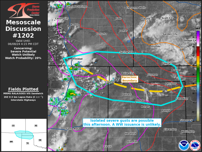
   Mesoscale Discussion 1202
   NWS Storm Prediction Center Norman OK
   0215 PM CDT Sat Jun 08 2024

   Areas affected...portions of far southeastern Colorado...extreme
   northeastern New Mexico...extreme southwestern Kansas...Oklahoma
   Panhandle...far northern Texas Panhandle

   Concerning...Severe potential...Watch unlikely

   Valid 081915Z - 082115Z

   Probability of Watch Issuance...20 percent

   SUMMARY...Isolated severe gusts may accompany the stronger storms
   this afternoon, with the greatest chance of storms occurring along a
   stationary boundary along the TX/OK Panhandles border area. Given
   the isolated nature of the severe threat, a WW issuance is not
   expected.

   DISCUSSION...Upslope flow over the Raton Mesa is contributing to
   convective initiation, with additional storm development likely as
   strong surface heating continues along an west-east oriented
   baroclinic boundary situated near the TX/OK Panhandle border.
   Surface temperatures near this boundary are approaching 100 F amid
   50-60 F surface dewpoints, resulting in the development of a deep
   boundary layer. RAP forecast soundings show classic inverted-V
   profiles extending up to 600 mb. 8+ C/km tropospheric lapse rates
   support thin CAPE profiles, from 600-200 mb, atop the deep boundary
   layer. Given relatively weak deep-layer shear, mainly pulse-cellular
   storms with dry microburst potential are expected, with the best
   chance of storms being along the baroclinic zone. Given the overall
   isolated coverage of thunderstorms and associated severe gust
   potential, a WW issuance is not anticipated.

   ..Squitieri/Gleason.. 06/08/2024

   ...Please see www.spc.noaa.gov for graphic product...

   ATTN...WFO...DDC...AMA...PUB...ABQ...

   LAT...LON   37220483 37460352 37390139 36980038 36340010 35890039
               35750095 35840179 35920287 36070357 36390430 37220483
|
|
Top/All Mesoscale Discussions/Forecast Products/Home
|
|


 @NWSSPC