|
| Mesoscale Discussion 1211 |
|
< Previous MD Next MD >
|
|
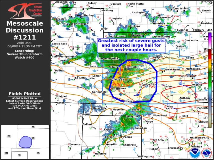
   Mesoscale Discussion 1211
   NWS Storm Prediction Center Norman OK
   1003 PM CDT Sat Jun 08 2024

   Areas affected...Portions of southwest Kansas

   Concerning...Severe Thunderstorm Watch 400...

   Valid 090303Z - 090430Z

   The severe weather threat for Severe Thunderstorm Watch 400
   continues.

   SUMMARY...The risk of severe gusts and isolated large hail will
   continue spreading eastward across southwest Kansas tonight. 60-70
   mph gusts are expected, with isolated gusts up to 80 mph possible.

   DISCUSSION...A cluster of organized storms that tracked eastward out
   of southeastern CO is showing signs of upscale growth, given recent
   downstream warm-advection-driven convection. Strong low-level
   veering winds (sampled by DDC VWP) suggests warm-air advection may
   further aid in upscale growth. Ahead of this convection, antecedent
   heating of a moist boundary layer (middle/upper 60s dewpoints),
   beneath a plume of steep midlevel lapse rates, has yielded a
   favorable east/west-oriented axis of moderate surface-based
   instability. As the upscale-growing cluster tracks eastward across
   this instability, the cold pool may become more organized, given
   around 40 kt of line-orthogonal effective shear. The primary risk
   should be severe gusts of 60-70 mph, with isolated gusts up to 80
   mph possible. Isolated large hail and perhaps a brief tornado or two
   will also be possible with any embedded stronger rotating cores.

   ..Weinman.. 06/09/2024

   ...Please see www.spc.noaa.gov for graphic product...

   ATTN...WFO...DDC...GLD...

   LAT...LON   37930158 38570120 38830075 38870023 38699949 38359917
               37559920 37119955 37070036 37120106 37290148 37600169
               37930158
|
|
Top/All Mesoscale Discussions/Forecast Products/Home
|
|


 @NWSSPC