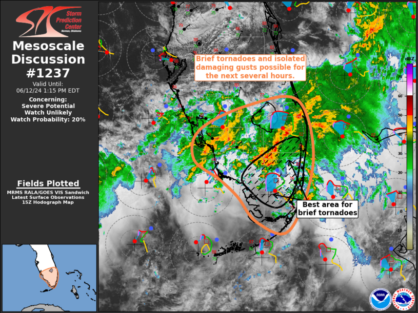
   Mesoscale Discussion 1237
   NWS Storm Prediction Center Norman OK
   1009 AM CDT Wed Jun 12 2024

   Areas affected...South FL

   Concerning...Severe potential...Watch unlikely

   Valid 121509Z - 121715Z

   Probability of Watch Issuance...20 percent

   SUMMARY...Brief tornadoes and isolated damaging gusts are possible
   across south Florida for the next several hours.

   DISCUSSION...Recent radar imagery has revealed low-level rotation
   within some of the shallow, more cellular convection across southern
   FL, particularly near the intersection of Collier, Broward, and
   Miami-Dade counties. These showers and thunderstorms are being
   initiated by warm-air advection, but are quickly becoming surface
   based with the very moist and uncapped airmass across the region.
   Buoyancy is modest (i.e. around 1500-2000 J/kg of MLCAPE), promoted
   by shallow but vertically deep thermodynamic profiles. This buoyancy
   is more than sufficient for deep updrafts capable of lightning.
   Additionally, the AMX VAD profiles show notable low-level veering,
   with 20 to 25 kt of 0-1 km storm-relative helicity sampled recently.
   There may also be some ambient vertical vorticity within the
   low-level environment, given the presence of storm outflow and
   low-level convergence that is occurring, particularly to the south
   of the main precipitation shield. As result, there is likely a
   mesoscale corridor of greater tornado potential across from Mainland
   Monroe County northeastward into southern Palm Beach County.
   Water-loaded downbursts are also possible across much of south FL.

   ..Mosier/Goss.. 06/12/2024

   ...Please see www.spc.noaa.gov for graphic product...

   ATTN...WFO...MFL...MLB...KEY...TBW...

   LAT...LON   25138100 25568138 25868172 26208222 26718212 27158120
               27238021 26157992 24998038 25138100
|


 @NWSSPC