|
| Mesoscale Discussion 1243 |
|
< Previous MD Next MD >
|
|
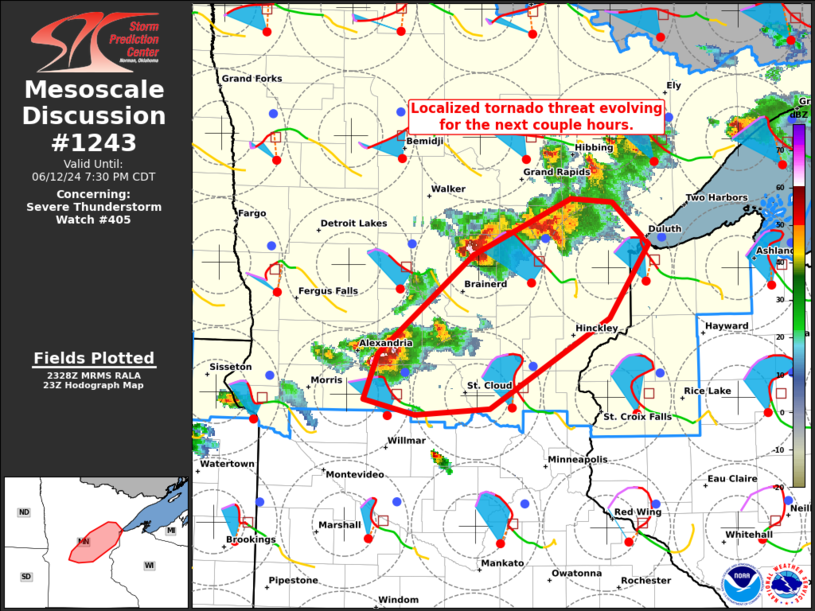
   Mesoscale Discussion 1243
   NWS Storm Prediction Center Norman OK
   0631 PM CDT Wed Jun 12 2024

   Areas affected...Portions of central and eastern Minnesota

   Concerning...Severe Thunderstorm Watch 405...

   Valid 122331Z - 130030Z

   The severe weather threat for Severe Thunderstorm Watch 405
   continues.

   SUMMARY...A localized tornado threat is evolving over portions of
   central/eastern Minnesota. The area is being considered for a small
   tornado watch.

   DISCUSSION...Following several splitting supercells along a surface
   trough/wind shift over central/eastern MN, latest radar data shows
   dominant right-moving thunderstorms taking shape. This evolution is
   being aided by an increasingly large, clockwise-turning low-level
   hodograph (around 300 m2/s2 0-1 km SRH per MPX VWP). Given this
   hodograph and favorable low-level moisture in place downstream of
   the intensifying storms, a localized tornado risk is possible for
   the next couple hours. The area is being considered for a small
   tornado watch.

   ..Weinman/Smith.. 06/12/2024

   ...Please see www.spc.noaa.gov for graphic product...

   ATTN...WFO...DLH...MPX...

   LAT...LON   46649407 47079295 47049249 46719207 46149253 45439387
               45389472 45499529 45859514 46649407
|
|
Top/All Mesoscale Discussions/Forecast Products/Home
|
|


 @NWSSPC