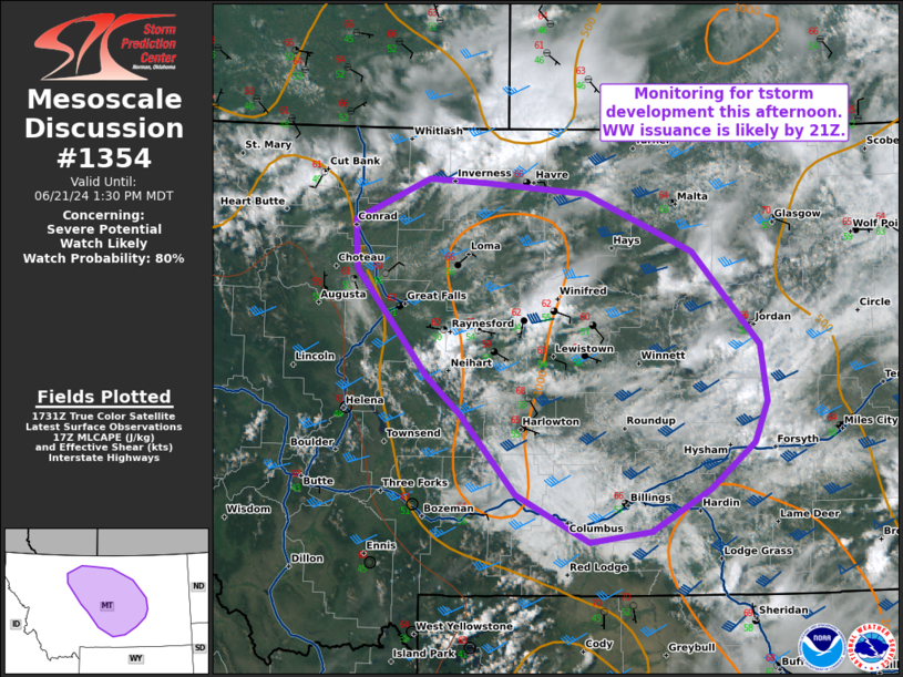
   Mesoscale Discussion 1354
   NWS Storm Prediction Center Norman OK
   1235 PM CDT Fri Jun 21 2024

   Areas affected...Central Montana

   Concerning...Severe potential...Watch likely

   Valid 211735Z - 211930Z

   Probability of Watch Issuance...80 percent

   SUMMARY...A WW will likely be needed for Central MT this afternoon
   as a few isolated supercells develop over the high terrain and move
   east into an environment supportive of all severe hazards.

   DISCUSSION...The current water vapor loop coupled with the RAP
   upper-air analysis shows a subtle shortwave trough/vort max
   approaching the Northern Rockies, with some morning convection
   ongoing ahead of the wave. The boundary layer south and east of the
   ongoing convection is characterized by mid 60s F surface
   temperatures and mid-to-upper 50s F dewpoints, beneath steep
   mid-level lapse rates of 8-9 C/km that are supportive of deep
   convection later this afternoon. Morning soundings and SPC
   Mesoanalysis indicate deep layer shear of 35-45 kts, suggesting
   multicellular and supercellular storm modes are likely.

   While ongoing convection over Judith Basin County appears to be
   weakening, visible satellite indicates another region of developing
   cumulus further to the west within a local minima of MLCINH,
   suggesting additional development is likely within the next few
   hours. RAP forecast profiles later this afternoon in Central MT
   indicate buoyancy will increase to 2000 J/kg MLCAPE with deep layer
   shear in the 45-50 kt range, suggesting a threat for supercells
   capable of primarily damaging wind and hail, though also supportive
   of tornadoes. Hodographs in South-Central MT are primarily
   straight-line, indicating the potential for splitting supercells
   capable of all hazards, while further north hodographs take on a
   more curved shape in the low levels, supportive of a right-moving
   supercell tornado threat.

   Overall storm coverage is uncertain at this time, but a WW will
   likely be needed later this afternoon for a few supercells that
   develop and track eastward throughout the day, capable of all
   hazards.

   ..Halbert/Weinman/Hart.. 06/21/2024

   ...Please see www.spc.noaa.gov for graphic product...

   ATTN...WFO...BYZ...GGW...TFX...

   LAT...LON   48211193 48561099 48531030 48450901 47950766 47140682
               46660674 46310690 45900747 45540820 45460896 45870988
               46561058 46881100 47781190 48211193
|


 @NWSSPC