|
| Mesoscale Discussion 1356 |
|
< Previous MD Next MD >
|
|
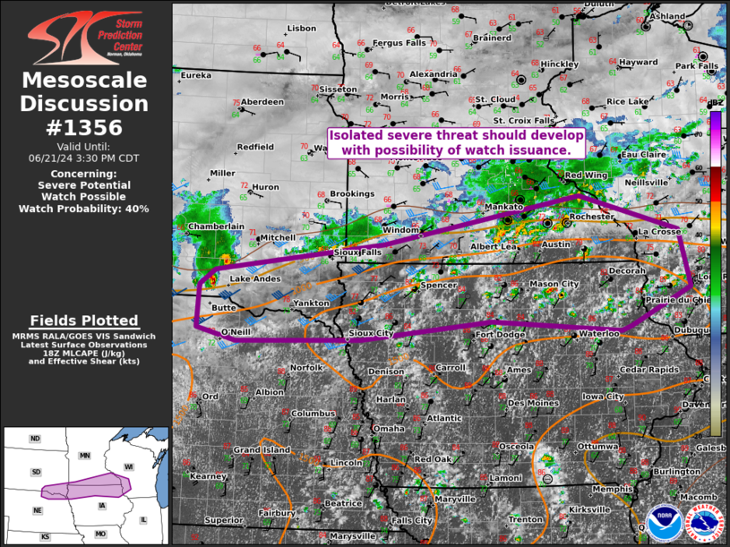
   Mesoscale Discussion 1356
   NWS Storm Prediction Center Norman OK
   0125 PM CDT Fri Jun 21 2024

   Areas affected...parts of the Mid-MO to Upper MS Valley

   Concerning...Severe potential...Watch possible

   Valid 211825Z - 212030Z

   Probability of Watch Issuance...40 percent

   SUMMARY...A generally isolated severe threat should develop into
   late afternoon with a mix of wind/hail, along with a couple
   tornadoes possible. Uncertainty exists with the overall spatial
   extent of the severe threat with slow-moving storms expected.

   DISCUSSION...Convection is slowly increasing along a
   quasi-stationary/slow-moving warm front that arcs from northeast NE
   into far southeast MN and southwest WI. The eastern portion of this
   development appears to be primarily driven by modest low-level warm
   theta-e advection within an uncapped, moderately buoyant air mass.
   Convection farther west over the Mid-MO Valley is also being aided
   by a minor MCV in southeast SD. Area VWPs still indicate relatively
   stronger mid/upper flow is likely displaced along and to the cool
   side of the front, with weak flow into the warm-moist sector. A
   confined corridor of slow-moving, transient supercells and multicell
   clusters should develop near and just south of the front. Overall
   severe coverage will probably remain sporadic with mainly a
   lower-end wind/hail threat. Confidence is somewhat higher in
   intensification, including the potential for a couple tornadoes, in
   association with the MCV over the Mid-MO Valley.

   ..Grams/Hart.. 06/21/2024

   ...Please see www.spc.noaa.gov for graphic product...

   ATTN...WFO...MKX...DVN...ARX...MPX...DMX...FSD...OAX...LBF...

   LAT...LON   44379225 43909048 43159028 42659136 42609154 42749384
               42489615 42449837 42599907 43169904 43359876 43749576
               44379225
|
|
Top/All Mesoscale Discussions/Forecast Products/Home
|
|


 @NWSSPC