|
| Mesoscale Discussion 1365 |
|
< Previous MD Next MD >
|
|
Mesoscale Discussion 1365
NWS Storm Prediction Center Norman OK
0531 PM CDT Fri Jun 21 2024
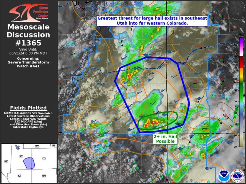
Areas affected...Southeastern Utah and far western Colorado
Concerning...Severe Thunderstorm Watch 441...
Valid 212231Z - 220000Z
The severe weather threat for Severe Thunderstorm Watch 441
continues.
SUMMARY...Large to very-large hail and isolated strong/severe winds
are most likely in parts of southeast Utah and adjacent western
Colorado.
DISCUSSION...Though the mid-level trough is continuing to lose
amplitude with time, strong mid-level winds should continue to
persist in the eastern Great Basin. At present, the most undisturbed
airmass is roughly within southeastern Utah into adjacent far
western Colorado. A supercell in San Juan County remains the
strongest storm in the area and will be most capable of producing 2+
inch hail in the short term. Other storms in the Emery/Grand
Counties vicinity may intensify and pose a threat for large hail as
well. As storms move farther into the western slope, buoyancy will
be decreased and storm intensity should wane. Elsewhere in WW 441,
cloud cover/outflow has had some impact and storms have not been as
intense in the last hour. However, isolated large hail and
strong/severe winds could occur if any of that peripheral activity
intensifies.
..Wendt.. 06/21/2024
...Please see www.spc.noaa.gov for graphic product...
ATTN...WFO...GJT...SLC...
LAT...LON 37051005 38551101 38961081 39270981 39240893 39070864
37900822 37530832 37280846 37140896 37070953 37051005
|
|
Top/All Mesoscale Discussions/Forecast Products/Home
|
|


 @NWSSPC