|
| Mesoscale Discussion 1372 |
|
< Previous MD Next MD >
|
|
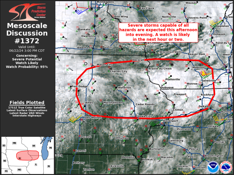
   Mesoscale Discussion 1372
   NWS Storm Prediction Center Norman OK
   1256 PM CDT Sat Jun 22 2024

   Areas affected...Portions of northeastern IA...northern IL...and
   southern WI

   Concerning...Severe potential...Watch likely

   Valid 221756Z - 222000Z

   Probability of Watch Issuance...95 percent

   SUMMARY...Severe storms capable of producing damaging winds, a
   couple tornadoes, and isolated large hail are expected this
   afternoon into the evening. A watch is likely in the next hour or
   two.

   DISCUSSION...Latest visible satellite imagery indicates filtered
   diurnal heating/destabilization of a very moist boundary layer
   (middle 70s dewpoints) along/south of an east/west-oriented
   stationary boundary extending across portions of northern IA into
   southern WI. Over the next couple hours, a weak frontal wave
   currently near far northwest IA will track eastward along the
   boundary, promoting scattered thunderstorm development -- aided by
   the aforementioned destabilization and modest midlevel height falls
   ahead of a midlevel trough.

   Around 50 kt of midlevel westerly flow atop a 30-40-kt southwesterly
   low-level jet (per regional VWP) will promote organized
   surface-based storms (including a few supercells) near the boundary.
   Easterly storm motions and deep-layer shear parallel to the boundary
   may favor congealing cold pools and localized upscale growth, though
   the favorable shear profile (large clockwise-curved low-level
   hodographs) should encourage a few sustained semi-discrete
   supercells. Damaging winds up to 70 mph, a couple tornadoes, and
   isolated large hail are all possible with this activity. Current
   thinking is that severe storms will develop/mature in the 19-20Z
   time frame and persist into the evening hours. A watch is likely for
   parts of the area in the next hour or two.

   ..Weinman/Hart.. 06/22/2024

   ...Please see www.spc.noaa.gov for graphic product...

   ATTN...WFO...LOT...MKX...DVN...ARX...DMX...

   LAT...LON   41729328 41889371 42309395 42769393 43079356 43249277
               43389085 43338912 43088858 42328852 41908884 41708959
               41649094 41679239 41729328
|
|
Top/All Mesoscale Discussions/Forecast Products/Home
|
|


 @NWSSPC