|
| Mesoscale Discussion 1383 |
|
< Previous MD Next MD >
|
|
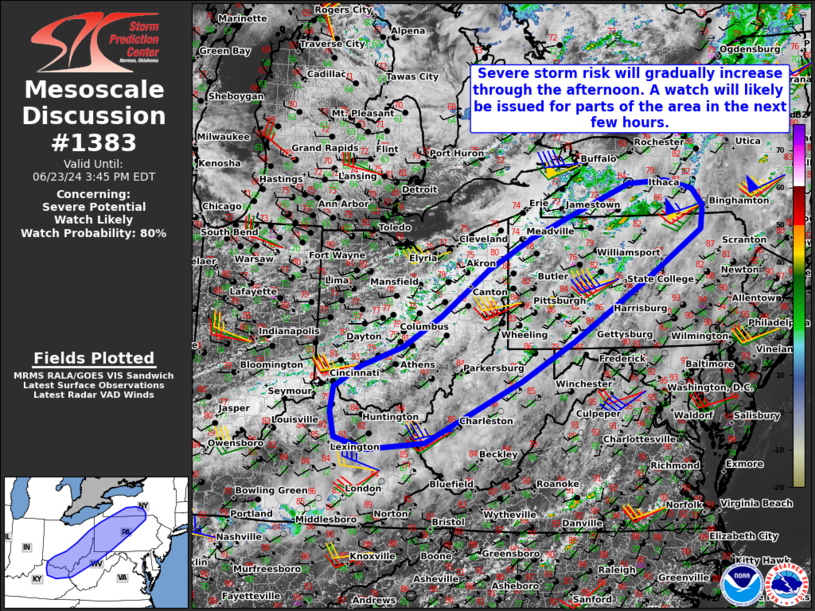
   Mesoscale Discussion 1383
   NWS Storm Prediction Center Norman OK
   1242 PM CDT Sun Jun 23 2024

   Areas affected...Portions of the Ohio River Valley into southern New
   York

   Concerning...Severe potential...Watch likely

   Valid 231742Z - 231945Z

   Probability of Watch Issuance...80 percent

   SUMMARY...Severe storm risk will gradually increase through the
   afternoon, with damaging winds being the primary concern. A watch
   will likely be issued for parts of the area in the next few hours.

   DISCUSSION...Ahead of a northeast/southwest-oriented cold front
   draped across the OH River Valley, a corridor of upper 60s to lower
   70s dewpoints and pockets of heating will contribute to moderate
   surface-based instability -- despite poor midlevel lapse rates
   sampled by 12Z observed soundings. As modest midlevel height falls
   overspread the region, surface-based thunderstorms should gradually
   increase in coverage along/ahead of the cold front.

   Storms should slowly increase in intensity as they track eastward
   and intercept the destabilizing warm/moist sector. Given ample
   deep-layer westerly flow/shear (around 35-kt effective shear)
   roughly perpendicular to the front, a mix of loosely organized
   clusters and transient supercells are expected. Steepening low-level
   lapse rates and the enhanced low/midlevel flow will favor locally
   damaging gusts as the primary concern, especially with any localized
   upscale growth. However, marginally severe hail and a tornado or two
   cannot be ruled out, especially with any sustained semi-discrete
   supercells. A watch (potentially two separate watches) will likely
   be issued for parts of the area in the next few hours.

   ..Weinman/Hart.. 06/23/2024

   ...Please see www.spc.noaa.gov for graphic product...

   ATTN...WFO...BGM...BUF...CTP...LWX...PBZ...RLX...CLE...JKL...
   ILN...LMK...

   LAT...LON   40268200 41078095 41647995 42107886 42557771 42607687
               42437624 42137602 41737607 40937729 40347822 39857898
               39158017 38068234 37938362 38138434 38578444 39018438
               39378380 39738286 40268200
|
|
Top/All Mesoscale Discussions/Forecast Products/Home
|
|


 @NWSSPC