|
| Mesoscale Discussion 1400 |
|
< Previous MD Next MD >
|
|
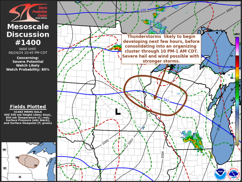
   Mesoscale Discussion 1400
   NWS Storm Prediction Center Norman OK
   0850 PM CDT Mon Jun 24 2024

   Areas affected...east central Minnesota into northwestern Wisconsin

   Concerning...Severe potential...Watch likely

   Valid 250150Z - 250345Z

   Probability of Watch Issuance...80 percent

   SUMMARY...Thunderstorm initiation appears increasingly probable
   during the next hour or two, with a substantive further increase and
   intensification of storms through 10 PM-1 AM CDT.  Initial storms
   may pose a risk for large hail, before the risk for potentially
   damaging wind gusts increases overnight.

   DISCUSSION...Deepening convective development is evident within
   strengthening warm advection across central Minnesota into
   northwestern Wisconsin.  The warm frontal zone has shifted northward
   some over the past several hours, but convection has been struggling
   to overcome inhibition associated with very warm/dry elevated
   mixed-layer air, despite further low-level moistening.  However, as
   mid/upper flow transitions from broadly anticyclonic to broadly
   cyclonic, and low-level warm advection strengthens further in
   response to an intensifying low-level jet, lift appears likely to
   increasingly overcome inhibition.  This probably will allow for a
   substantive increase in thunderstorm development through the 03-06Z
   time frame.  Initial development may include evolving elevated
   supercells posing a risk for large hail, before activity gradually
   consolidates and grows upscale into an organizing cluster with
   increasing potential to produce damaging wind gusts later tonight.

   ..Kerr/Gleason.. 06/25/2024

   ...Please see www.spc.noaa.gov for graphic product...

   ATTN...WFO...GRB...DLH...ARX...MPX...

   LAT...LON   46329383 46389212 45518962 44379066 44759290 45539427
               46329383
|
|
Top/All Mesoscale Discussions/Forecast Products/Home
|
|


 @NWSSPC