|
| Mesoscale Discussion 1445 |
|
< Previous MD Next MD >
|
|
Mesoscale Discussion 1445
NWS Storm Prediction Center Norman OK
0118 PM CDT Thu Jun 27 2024
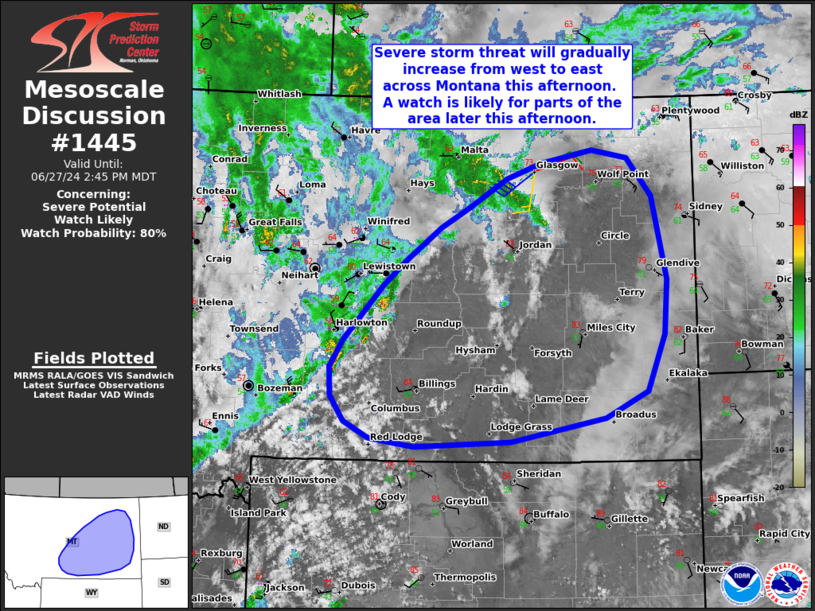
Areas affected...Portions of central and eastern Montana
Concerning...Severe potential...Watch likely
Valid 271818Z - 272045Z
Probability of Watch Issuance...80 percent
SUMMARY...The severe-storm threat will gradually increase from west
to east across portions of central and eastern Montana this
afternoon. Large hail and severe gusts are the main concerns. A
watch will likely be needed for parts of the area later this
afternoon.
DISCUSSION...Latest water-vapor imagery indicates a band of
large-scale ascent overspreading west/central MT -- ahead of a
midlevel trough/low tracking eastward across the Northwest. At the
leading edge of this ascent, isolated to widely scattered
thunderstorms are tracking east-northeastward along the higher
terrain in west/central MT. Over the next several hours, this
activity will continue spreading eastward across central into
eastern MT, generally in tandem with the large-scale ascent.
Additional development is also possible in areas of differential
heating farther east. Ample diurnal heating/destabilization beneath
steep midlevel lapse rates (sampled by 12Z regional soundings) will
erode remaining low-level inhibition and promote a gradual uptick in
updraft intensity through the afternoon.
Around 50 kt of effective shear associated with the
eastward-advancing trough will support storm organization, and a
mostly straight hodograph should favor a mix of splitting supercell
structures and organized clusters. Large hail (some potentially 2+
inches) and severe outflow winds are possible with the strongest
storms. The risk of severe gusts (some 75+ mph) should increase with
eastward extent, especially with any upscale-growing clusters. While
a brief tornado cannot be entirely ruled out in this area, the
more-favorable tornado environment should generally develop over
areas farther east (far eastern MT into the Dakotas), where richer
boundary-layer moisture and curved hodographs are expected.
A watch is likely for portions of the area later this afternoon,
though timing of issuance is a bit uncertain at this time.
..Weinman/Hart.. 06/27/2024
...Please see www.spc.noaa.gov for graphic product...
ATTN...WFO...BYZ...GGW...TFX...
LAT...LON 46320967 46920906 47200870 47580813 47800768 48110706
48290651 48430569 48330512 47910473 46990450 46390455
45770483 45470550 45220700 45160853 45240924 45430965
45710987 46030989 46320967
|
|
Top/All Mesoscale Discussions/Forecast Products/Home
|
|


 @NWSSPC