|
| Mesoscale Discussion 1447 |
|
< Previous MD Next MD >
|
|
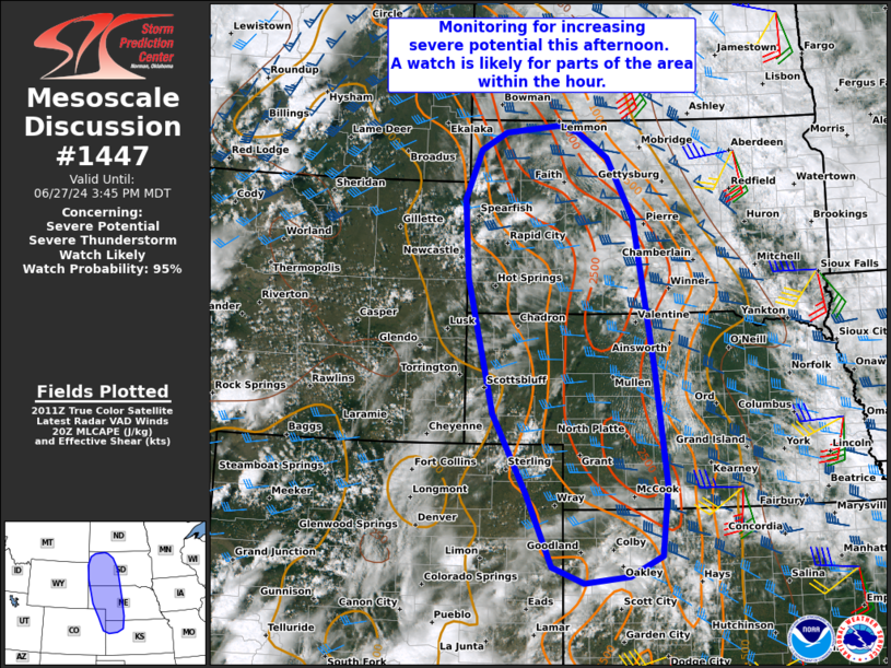
   Mesoscale Discussion 1447
   NWS Storm Prediction Center Norman OK
   0318 PM CDT Thu Jun 27 2024

   Areas affected...Portions of the central and northern High Plains

   Concerning...Severe potential...Severe Thunderstorm Watch likely

   Valid 272018Z - 272145Z

   Probability of Watch Issuance...95 percent

   SUMMARY...Monitoring the area for increasing severe-storm potential
   this afternoon. A watch will be needed for parts of the area within
   the hour.

   DISCUSSION...Deepening boundary-layer cumulus is evident in the
   vicinity of the Black Hills as well as far northeast CO into the NE
   Panhandle this afternoon -- generally focused along a lee
   trough/surface wind shift. During the next couple hours, the lee
   trough will deepen as midlevel westerly flow strengthens across the
   northern and central Rockies. This will support a gradual increase
   in thunderstorm development over the next few hours, given diurnal
   heating of a moist air mass (upper 50s to middle/upper 60s
   dewpoints) and removal of MLCINH along the lee trough.

   Storms should generally track eastward into the increasingly rich
   moisture, where steep midlevel lapse rates are yielding moderate
   surface-based instability. The 19Z UNR special sounding showed
   around 30 kt of effective shear, characterized by a long/mostly
   straight hodograph, and deep-layer shear should strengthen to around
   40-50 kt with time. As a result, storms should organize into
   semi-discrete supercells and organized clusters, with a risk of very
   large hail (potentially up to 3 inches) and severe gusts.

   A watch issuance is likely for parts of the area within the hour.

   ..Weinman/Hart.. 06/27/2024

   ...Please see www.spc.noaa.gov for graphic product...

   ATTN...WFO...ABR...GID...LBF...UNR...GLD...BOU...CYS...

   LAT...LON   43520402 44730412 45490378 45760326 45860213 45770174
               45370112 44440058 42140017 40379993 39270005 38960071
               38860163 39110228 40230279 41450348 43520402
|
|
Top/All Mesoscale Discussions/Forecast Products/Home
|
|


 @NWSSPC