|
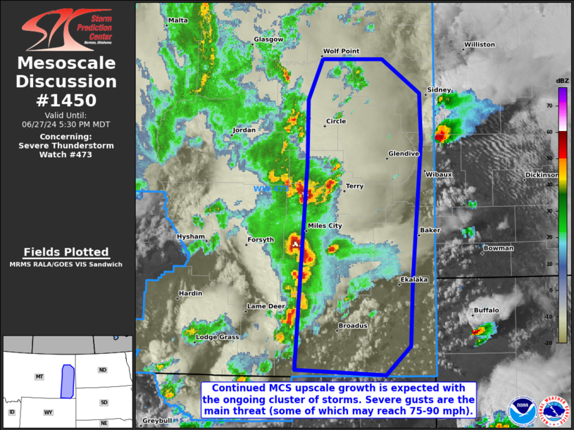
| Mesoscale Discussion 1450 |
|
< Previous MD Next MD >
|

|
   Mesoscale Discussion 1450
   NWS Storm Prediction Center Norman OK
   0501 PM CDT Thu Jun 27 2024

   Areas affected...Portions of southeastern Montana

   Concerning...Severe Thunderstorm Watch 473...

   Valid 272201Z - 272330Z

   The severe weather threat for Severe Thunderstorm Watch 473
   continues.

   SUMMARY...The severe threat continues across Severe Thunderstorm
   Watch 473. Severe wind gusts (a few of which could reach 75-90 mph)
   are the main threat, though isolated instances of hail or even a
   tornado remain possible.

   DISCUSSION...Multicells and transient supercells are merging into a
   singular MCS across portions of southeastern Montana. These storms
   have been traversing a mixed boundary layer (characterized by 9.5
   C/km 0-3 km lapse rates per 21Z mesoanalysis), with a history of
   producing multiple severe gusts. Preceding the upscale growing MCS
   is a warm sector that moistens with eastward extent, with 60s F
   dewpoints beneath 7.5 C/km mid-level lapse rates contributing to
   2000-3000 J/kg MLCAPE near the MT/ND border. Given widespread 50+ kt
   effective bulk shear, the MCS should at least maintain intensity
   through the evening. However, deep-layer shear vectors become more
   perpendicular to MCS orientation with eastward extent, which may
   promote further organization into a bow-echo MCS with increased
   severe gust potential. A few 75-90 mph gusts may occur near the apex
   of any bow echo that can form, with large hail possible with any
   stronger storm cores. A tornado also cannot be ruled out with any
   mesovortices that can become established.

   ..Squitieri.. 06/27/2024

   ...Please see www.spc.noaa.gov for graphic product...

   ATTN...WFO...BYZ...GGW...

   LAT...LON   45050599 47040582 47670582 48050561 48050477 47730424
               47270422 45910436 45280439 45010473 45050599
|
|
Top/All Mesoscale Discussions/Forecast Products/Home
|
|


