|
| Mesoscale Discussion 1479 |
|
< Previous MD Next MD >
|
|
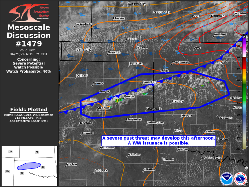
   Mesoscale Discussion 1479
   NWS Storm Prediction Center Norman OK
   0444 PM CDT Sat Jun 29 2024

   Areas affected...portions of the Texas Panhandle into northwestern
   Oklahoma

   Concerning...Severe potential...Watch possible

   Valid 292144Z - 292315Z

   Probability of Watch Issuance...40 percent

   SUMMARY...An increase in thunderstorm coverage and intensity is
   anticipated within the next few hours. The stronger storms may
   produce at least a few severe gusts, and an instance or two of large
   hail also cannot be ruled out. Convective trends are being monitored
   for the need of a Severe Thunderstorm Watch issuance.

   DISCUSSION...A cold front continues to sag southward across the
   southern Plains, with agitated CU and hints at convective initiation
   noted across northern portions of the TX Panhandle into
   north-central OK. South of the front, the boundary layer has
   deepened, with surface temperatures exceeding 100 F. The 30-40 F
   surface temperature/dewpoint spreads suggest that any storms that
   form will be high-based, with 0-3 km lapse rates exceeding 9 C/km.
   As such, despite moderate vertical wind shear ahead of the front,
   adequate buoyancy (i.e. 2000-4000 J/kg MLCAPE) and the steep
   low-level lapse rates will foster severe gust potential with the
   strongest downbursts via evaporative cooling beneath the high cloud
   bases. A couple of the initial multicellular updrafts may also
   briefly produce large hail, especially if any storm can become
   sustained immediately behind the cold front, where effective bulk
   shear is exceeding 40 kts.

   It is unclear how widespread the severe gust threat will become
   given limited vertical wind shear ahead of the surface front. As
   such, convective trends will continue to be monitored for locally
   higher severe gust potential and subsequent need for a Severe
   Thunderstorm Watch issuance.

   ..Squitieri/Smith.. 06/29/2024

   ...Please see www.spc.noaa.gov for graphic product...

   ATTN...WFO...OUN...AMA...

   LAT...LON   35440233 36160042 36249877 35969769 35619754 35309851
               35180007 35030156 35000198 35110230 35440233
|
|
Top/All Mesoscale Discussions/Forecast Products/Home
|
|


 @NWSSPC