|
| Mesoscale Discussion 1508 |
|
< Previous MD Next MD >
|
|
Mesoscale Discussion 1508
NWS Storm Prediction Center Norman OK
0600 PM CDT Mon Jul 01 2024
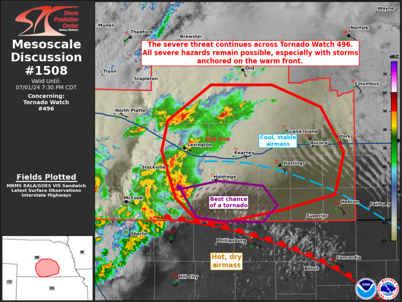
Areas affected...portions of south-central Nebraska
Concerning...Tornado Watch 496...
Valid 012300Z - 020030Z
The severe weather threat for Tornado Watch 496 continues.
SUMMARY...The severe threat continues across Tornado Watch 496. All
severe hazards are possible with the more dominant supercell
structures this evening, especially with any storms that can anchor
to the surface warm front.
DISCUSSION...Scattered multicells and at least one sustained
supercell have become established north of a surface warm front over
south-central NE. These storms continue to progress east-northeast
amid a strongly sheared and unstable airmass through evening. At the
moment, most of these storms are rooted above a stable boundary
layer north of the warm front. The supercell over Furnas County, NE
appears anchored on or immediately north of the surface warm front,
and this storm has the best potential to be surface based and
produce all severe hazards. Storms south of the warm front will
occur in a deep boundary layer and veered low-level flow, with
severe gusts the main threat. Storms north of the front should
remain elevated, accompanied by mainly a large hail threat, though a
severe gust cannot be ruled out.
..Squitieri.. 07/01/2024
...Please see www.spc.noaa.gov for graphic product...
ATTN...WFO...GID...LBF...
LAT...LON 39989923 40049963 40249988 40750008 41060000 41459940
41469852 41219783 40739751 40289764 40129840 39989923
|
|
Top/All Mesoscale Discussions/Forecast Products/Home
|
|


 @NWSSPC