|
| Mesoscale Discussion 1572 |
|
< Previous MD Next MD >
|
|
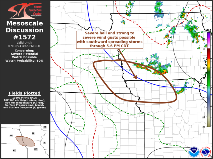
   Mesoscale Discussion 1572
   NWS Storm Prediction Center Norman OK
   0212 PM CDT Wed Jul 10 2024

   Areas affected...parts of southeastern Nebraska...southwestern
   Iowa...northwestern Missouri...northeastern Kansas

   Concerning...Severe potential...Watch possible

   Valid 101912Z - 102145Z

   Probability of Watch Issuance...60 percent

   SUMMARY...Increasing thunderstorm development may be accompanied by
   a risk for severe hail, and perhaps increasing potential for strong
   to locally severe gusts, while spreading southward through 5-6 PM
   CDT.

   DISCUSSION...Thunderstorm activity has recently begun to intensify
   across south central Iowa, likely in response to increasing inflow
   of a destabilizing boundary-layer air mass characterized by
   mixed-layer CAPE up to around 2000 J/kg.  This is occurring near the
   leading edge of a digging mid-level cold pool, which is forecast to
   continue spreading southward into the lower Missouri Valley through
   22-23Z.

   This is embedded within relatively modest (20-25 kt) deep-layer
   west-northwesterly to northwesterly flow, but shear along the
   southwestern flank of the associated weak surface cold pool may
   become increasingly conducive to the evolution of at least
   short-lived supercell structures.   New thunderstorm development is
   underway along this boundary, in the wake of the lead forward
   propagating cluster, and further intensification of this activity
   seems probable during the next few hours.  In the presence of
   relatively steep lower/mid-tropospheric lapse rates, stronger cells
   may pose a risk for severe hail, and the risk for locally strong to
   severe surface gusts may also become more prominent by early
   evening.

   ..Kerr/Guyer.. 07/10/2024

   ...Please see www.spc.noaa.gov for graphic product...

   ATTN...WFO...DMX...EAX...OAX...TOP...GID...

   LAT...LON   41439707 41439647 41429570 40909372 39719284 39669500
               39949625 41199752 41439707
|
|
Top/All Mesoscale Discussions/Forecast Products/Home
|
|


 @NWSSPC