|
| Mesoscale Discussion 1657 |
|
< Previous MD Next MD >
|
|
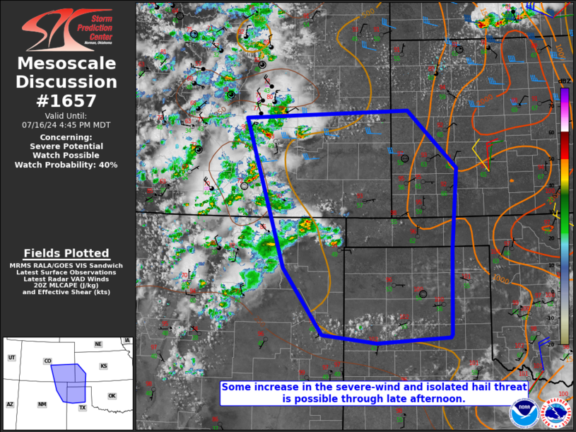
   Mesoscale Discussion 1657
   NWS Storm Prediction Center Norman OK
   0349 PM CDT Tue Jul 16 2024

   Areas affected...Southeast CO...northeast NM...southwest KS...TX/OK
   Panhandles

   Concerning...Severe potential...Watch possible

   Valid 162049Z - 162245Z

   Probability of Watch Issuance...40 percent

   SUMMARY...Some increase in the severe-wind and isolated hail threat
   is possible through late afternoon into early evening.

   DISCUSSION...Convection developing near the higher terrain of
   south-central CO into northeast NM has gradually intensified this
   afternoon, with a recent measured gust of 51 kt at Colorado Springs.
   Farther east, storms are beginning to develop across parts of
   southeast CO into the Raton Mesa vicinity. Low-level moisture is
   generally rather modest across the region, but strong heating has
   resulted in MLCAPE increasing to 500-1000 J/kg, with some further
   increase possible into late afternoon. Modest northwesterly midlevel
   flow along the periphery of an upper ridge over the southern Rockies
   is supporting effective shear of 25-35 kt, which may support
   occasional storm organization.

   Initial discrete storms will continue to pose a threat of isolated
   severe gusts and possibly some hail. With time, increasingly
   prominent outflow within the initially hot and well-mixed
   environment will support development of one or more loosely
   organized clusters, which would move southeastward with some
   increase in the severe-wind threat into parts of the
   central/southern High Plains. Watch issuance is possible over parts
   of the region, if a more organized severe threat appears imminent.

   ..Dean/Hart.. 07/16/2024

   ...Please see www.spc.noaa.gov for graphic product...

   ATTN...WFO...DDC...GLD...AMA...PUB...BOU...ABQ...

   LAT...LON   38670512 38800169 37820065 36470076 35000080 34950082
               34860235 35000350 36140432 37070460 38670512
|
|
Top/All Mesoscale Discussions/Forecast Products/Home
|
|


 @NWSSPC