|
| Mesoscale Discussion 1676 |
|
< Previous MD Next MD >
|
|
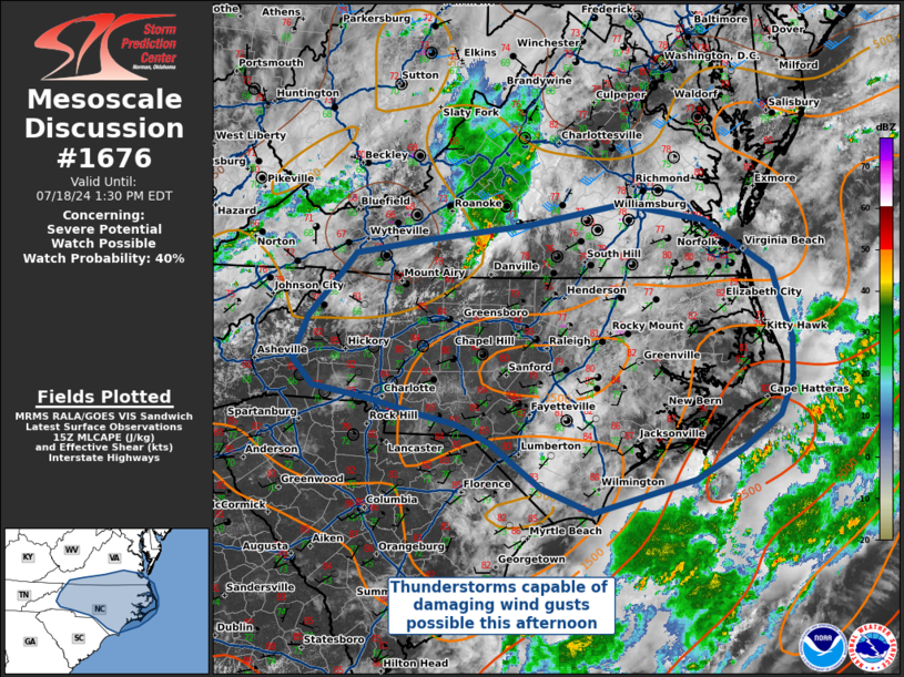
   Mesoscale Discussion 1676
   NWS Storm Prediction Center Norman OK
   1030 AM CDT Thu Jul 18 2024

   Areas affected...North Carolina into southern Virginia

   Concerning...Severe potential...Watch possible

   Valid 181530Z - 181730Z

   Probability of Watch Issuance...40 percent

   SUMMARY...Severe thunderstorms capable of damaging straight-line
   winds are possible this afternoon across much of North Carolina, as
   well as portions of southern Virginia. A severe thunderstorm watch
   may be needed later.

   DISCUSSION...Daytime heating and an ongoing MCS over southwestern
   Virginia will serve as the foci for convective development this
   afternoon. Morning observed soundings from MHX and GSO show moist,
   tropical profiles that will require very little daytime
   heating/mixing to convect. Short term model guidance and radar
   trends show intensification of the ongoing MCS in Virginia, which is
   expected to continue to move eastward across Virginia and
   potentially portions of northeastern North Carolina. Other storms
   will develop further south across North Carolina as the surface
   reaches convective temperatures.

   There is little in the way of upper-level support for organized
   convection, with observed soundings showing only 20 kts of
   deep-layer shear, and forecast profiles across North Carolina only
   ever approaching 30 kts. The expectation is for these storms to
   evolve into multi-cell clusters and loosely organized bowing
   segments, capable of damaging wind gusts. Additionally, the relative
   lack of shear combined with precipitable water vapor values at or
   exceeding the 90th percentile for the region, will result in an
   environment that supports water loaded updrafts collapsing into
   downbursts capable of severe winds.

   ..Halbert/Squitieri/Hart.. 07/18/2024

   ...Please see www.spc.noaa.gov for graphic product...

   ATTN...WFO...AKQ...MHX...RAH...ILM...RNK...GSP...

   LAT...LON   35338177 35628205 36098184 36638135 36798122 36948025
               37117888 37347761 37167649 36887603 36607559 36177544
               35867532 35407534 35027551 34667601 34317665 33957802
               34237871 34737940 34927987 35018028 35208109 35338177
|
|
Top/All Mesoscale Discussions/Forecast Products/Home
|
|


 @NWSSPC