|
| Mesoscale Discussion 1830 |
|
< Previous MD Next MD >
|
|
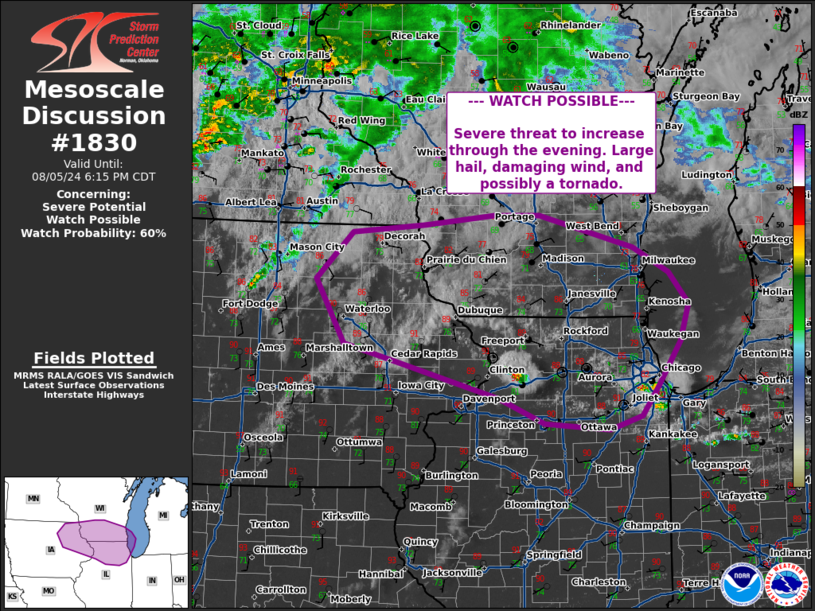
   Mesoscale Discussion 1830
   NWS Storm Prediction Center Norman OK
   0509 PM CDT Mon Aug 05 2024

   Areas affected...eastern Iowa...northern Illinois...southern
   Wisconsin

   Concerning...Severe potential...Watch possible

   Valid 052209Z - 052315Z

   Probability of Watch Issuance...60 percent

   SUMMARY...Severe threat to increase this evening. Damaging winds,
   large hail, and a tornado are possible.

   DISCUSSION...Surface analysis shows a front extending across the
   upper Ohio River Valley into portions of the Midwest. Visible
   satellite shows cu development along this boundary in eastern Iowa
   and northern Illinois, with a few cells now on radar south of
   Chicago and north of Davenport. The environment in this region is
   characterized by MLCAPE around 2000-2500 J/kg and deep layer shear
   along and north of the boundary around 40-45 kts. The 19z sounding
   profile from DVN further supports this, with around 2300 J/kg
   MLCAPE. Shear profiles are somewhat weak in the low-levels, with
   around 25-50 m2/s2 0-1km SRH in surface objective analysis. However,
   low level shear should increase through time to around 100-200 m2/s2
   per RAP forecasts. CAM guidance suggests a few supercells could
   develop, with potential for large hail, damaging wind, and perhaps a
   tornado. A watch may be needed to cover this threat for portions of
   this area in the next 1-2 hours.

   ..Thornton/Smith.. 08/05/2024

   ...Please see www.spc.noaa.gov for graphic product...

   ATTN...WFO...LOT...MKX...DVN...ARX...DMX...

   LAT...LON   43429220 43519112 43619009 43618941 43258800 42978748
               42628719 42228731 41728765 41408790 41248838 41328934
               41599001 41999155 42199232 42899275 43429220
|
|
Top/All Mesoscale Discussions/Forecast Products/Home
|
|


 @NWSSPC