|
| Mesoscale Discussion 2198 |
|
< Previous MD Next MD >
|

|
   Mesoscale Discussion 2198
   NWS Storm Prediction Center Norman OK
   0719 PM CST Sun Nov 03 2024

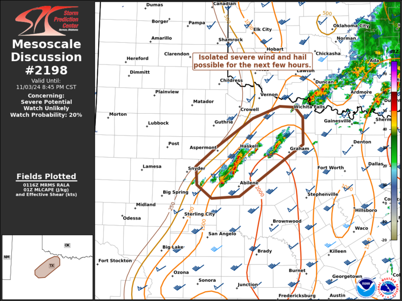
   Areas affected...Portions of northwest Texas

   Concerning...Severe potential...Watch unlikely

   Valid 040119Z - 040245Z

   Probability of Watch Issuance...20 percent

   SUMMARY...An isolated severe wind and hail risk may persist for a
   few more hours across portions of northwest Texas. The threat should
   remain too localized for a watch.

   DISCUSSION...A few loosely organized thunderstorm clusters are
   ongoing along a trailing northeast/southwest-oriented low-level
   confluence zone in northwest TX this evening. Nearby VWP data
   indicates around 50 kt of 0-6 km shear oriented parallel to the
   boundary, which combined with 1500 J/kg MLCAPE will continue to
   support loosely organized clusters for the next few hours. Isolated
   instances of severe hail (generally 1-1.75 inches) and locally
   severe gusts could accompany the stronger storms, though the risk
   appears too marginal/localized for a watch.

   ..Weinman/Smith.. 11/04/2024

   ...Please see www.spc.noaa.gov for graphic product...

   ATTN...WFO...FWD...OUN...SJT...LUB...MAF...

   LAT...LON   32460068 32830070 33200022 33769940 33989879 33969844
               33769825 33249825 32249971 32200034 32460068
|
|
Top/All Mesoscale Discussions/Forecast Products/Home
|
|


