|
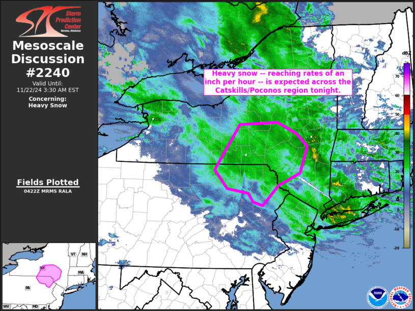
| Mesoscale Discussion 2240 |
|
< Previous MD Next MD >
|

|
   Mesoscale Discussion 2240
   NWS Storm Prediction Center Norman OK
   1023 PM CST Thu Nov 21 2024

   Areas affected...the Catskills and Poconos vicinity of northeastern
   Pennsylvania and southeastern New York

   Concerning...Heavy snow

   Valid 220423Z - 220830Z

   SUMMARY...Snowfall rates of an inch per hour are expected locally
   across parts of southeastern New York and northeastern Pennsylvania,
   specifically over the higher terrain in the Catskills and Poconos
   vicinity.

   DISCUSSION...As an upper low centered over southwestern Pennsylvania
   moves slowly east-southeastward, a surface low currently analyzed
   over the eastern Long Island vicinity will continue to retrograde
   northwestward across southern New England and eventually into
   southeastern New York.  Strong low-level warm advection north of the
   low is resulting in widespread moderate to heavy precipitation --
   mostly in the form of rain -- across southern New England and into
   eastern New York, northeastern Pennsylvania, and northern New
   Jersey.  However, temperatures near or slightly below freezing are
   indicated across the higher terrain areas including the Poconos and
   Catskills, where moderate to locally heavy snow is occurring
   (moderate snow is now being reported at the BGM obs site).

   Given the rather slow movement of the upper system, QG ascent across
   the discussion area should remain strong over the next 3 to 6 hours.
    As such, expect locally heavy snow -- at rates near an inch per
   hour -- to persist through midnight and into early Friday morning.

   ..Goss/Guyer.. 11/22/2024

   ...Please see www.spc.noaa.gov for graphic product...

   ATTN...WFO...ALY...PHI...BGM...CTP...

   LAT...LON   42677447 42397416 41817439 41547501 41107548 41177575
               41367590 41477650 41887688 42867614 42917505 42677447
|
|
Top/All Mesoscale Discussions/Forecast Products/Home
|
|


