|
| Mesoscale Discussion 2243 |
|
Next MD >
|

|
   Mesoscale Discussion 2243
   NWS Storm Prediction Center Norman OK
   0947 AM CST Thu Nov 28 2024

   Areas affected...parts of east central New York...southern
   Vermont...New Hampshire and southwestern Maine

   Concerning...Heavy snow

   Valid 281547Z - 281845Z

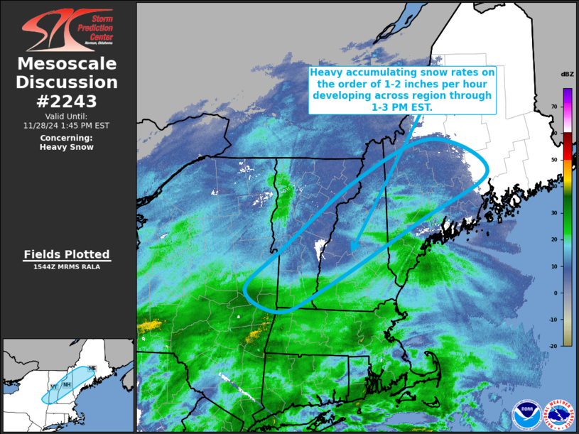
   SUMMARY...Heavy snow rates on the order of 1-2 inches per hour
   appear probable in a corridor from the vicinity of the Capital
   District of New York through the southern Green into White Mountains
   of Vermont and New Hampshire, into areas north of Portland ME
   through 1-3 PM EST.

   DISCUSSION...Rapid (2-4 mb 2-hourly) surface pressure falls are
   ongoing across the northern Mid Atlantic coast vicinity through
   southern New England, where substantive surface cyclogenesis is
   forecast to proceed beneath strengthening divergent flow between
   coupling upper jet streaks.  Downstream of a mid-level short wave
   trough pivoting into the northern Mid Atlantic region, models
   indicate strengthening upward vertical motion becoming maximized
   within a saturating layer near/just above 600 mb, where temperatures
   around -15C are conducive to large dendritic ice crystal growth.

   Thermodynamic profiles across the lower Hudson/Champlain Valley
   vicinity into New England are still largely sub-freezing, aside from
   a slowly deepening near-surface layer slowly advecting across the
   lower Hudson Valley into southern New England.  It appears that the
   near-surface environment will remain cold enough in a corridor
   (roughly) near/northeast of the Capital District of New York through
   the Portland ME to support heavy accumulating snow, which various
   model output indicates probably will include rates on the order of
   1-2 inches per hour.

   ..Kerr.. 11/28/2024

   ...Please see www.spc.noaa.gov for graphic product...

   ATTN...WFO...CAR...GYX...BTV...ALY...

   LAT...LON   42997395 43617318 44677165 45307005 44796886 44067030
               43067223 42667321 42997395
|
|
Top/All Mesoscale Discussions/Forecast Products/Home
|
|


