|
| Mesoscale Discussion 2256 |
|
< Previous MD Next MD >
|

|
   Mesoscale Discussion 2256
   NWS Storm Prediction Center Norman OK
   0954 AM CST Tue Dec 10 2024

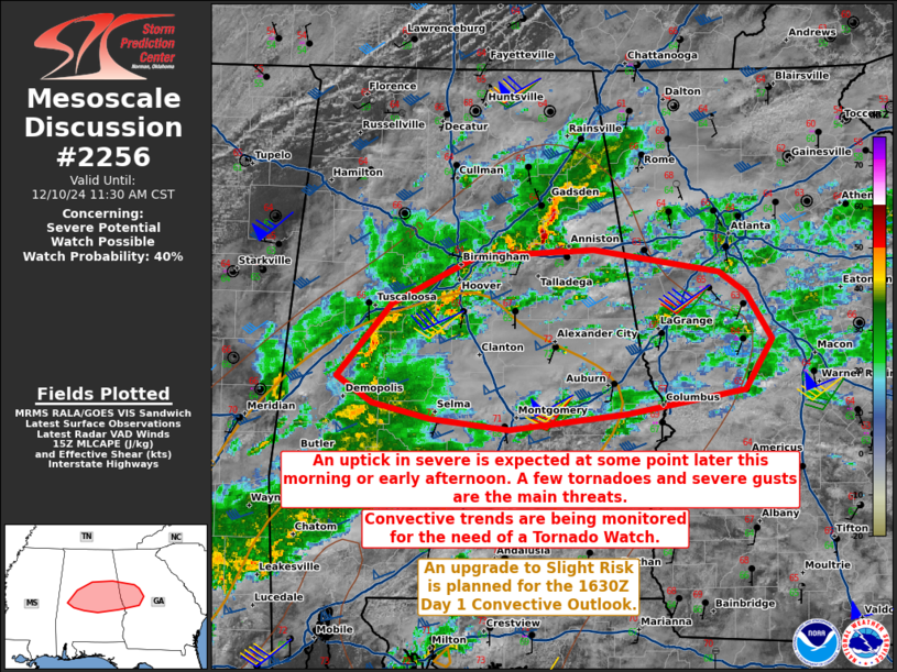
   Areas affected...portions of central Alabama into far western
   Georgia

   Concerning...Severe potential...Watch possible

   Valid 101554Z - 101730Z

   Probability of Watch Issuance...40 percent

   SUMMARY...The severe threat should continue to gradually increase
   through the morning, into the afternoon hours. A few tornadoes
   and/or severe gusts are the main threats. Convective trends are
   being monitored for the need of a Tornado Watch. An upgrade to a
   Slight Risk is also expected for portions of the region.

   DISCUSSION...Thunderstorms have gradually been increasing in
   coverage and intensity across central AL within a low-level moisture
   axis. Recently, a supercell structure has developed and may have
   produced a tornado in western AL. Immediately preceding these storms
   is a 30+ kt southwesterly LLJ that is expected to intensify into the
   late morning/early afternoon hours. At the same time, surface
   heating may boost MLCAPE over 500 J/kg amid upper 60s F surface
   dewpoints and modest tropospheric lapse rates. Latest observations
   show a diffuse baroclinic zone across central AL into far western
   GA. Here, hodographs will be most enlarged amid a potentially
   strengthening LLJ and aforementioned adequate buoyancy. Additional
   supercell structures are possible this afternoon, with a few
   tornadoes and severe gusts the main threats.

   Questions remain regarding when an uptick in severe may be realized
   (i.e. late morning vs. early afternoon), so it is unclear when a
   Tornado Watch may need to be issued. Convective trends will continue
   to be monitored for the need of a Tornado Watch at some point today.
   Furthermore, given the anticipated uptick in severe, a Slight Risk
   will be issued for the upcoming 1630Z Day 1 Convective Outlook.

   ..Squitieri/Hart.. 12/10/2024

   ...Please see www.spc.noaa.gov for graphic product...

   ATTN...WFO...FFC...BMX...

   LAT...LON   32948400 32578424 32388529 32268635 32348705 32478757
               32678789 33218741 33578665 33638560 33458447 33298423
               32948400
|
|
Top/All Mesoscale Discussions/Forecast Products/Home
|
|


