|
| Mesoscale Discussion 2275 |
|
< Previous MD Next MD >
|
|
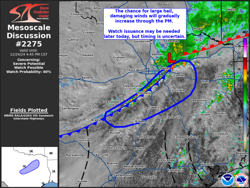
   Mesoscale Discussion 2275
   NWS Storm Prediction Center Norman OK
   0147 PM CST Tue Dec 24 2024

   Areas affected...Central Texas

   Concerning...Severe potential...Watch possible

   Valid 241947Z - 242245Z

   Probability of Watch Issuance...40 percent

   SUMMARY...A gradual uptick in convective intensity is anticipated
   through the afternoon and early evening hours across central Texas.
   Sporadic large hail and damaging wind gusts are possible in the
   short-term (next 1-3 hours) with watch issuance possible later this
   afternoon as the severe threat becomes more robust towards the TX
   Coastal Plain.

   DISCUSSION...Over the past 1-2 hours, convection has been slowly
   developing along a southeastward-moving cold front across northern
   to central TX. Modest destabilization and unfavorable storm
   mode/morphology have modulated convective intensities so far with
   only 0.25 to 0.5 inch hail reported via mPING. Broken cloud cover
   ahead of the front has allowed temperatures to warm into the low to
   mid 70s, which is promoting MLCAPE values upwards of 1000 J/kg
   across central TX. New convective towers/cells are developing to the
   southwest along the front into this more buoyant air mass, which
   should favor more intense convection compared to what's been
   observed in recent hours. Storm motions and deep-layer shear vectors
   oriented along the front will promote upscale growth into a line
   with time, but prior to this occurring a few more intense cells may
   pose a large hail risk, possibly as large as 1.0-1.5 inch.
   Convective intensity is expected to gradually increase through the
   late afternoon and evening amid continued diurnal heating and
   northward moisture flux. Watch issuance may eventually be needed
   this afternoon as convection intensifies, though timing remains
   uncertain.

   ..Moore/Hart.. 12/24/2024

   ...Please see www.spc.noaa.gov for graphic product...

   ATTN...WFO...SHV...FWD...EWX...SJT...

   LAT...LON   32329728 32739679 32959636 33089601 33059570 32929554
               32739547 32499545 32249550 32019567 31829597 31569654
               31349708 31119764 31019809 30999845 31109867 31189879
               31299882 31459877 31659836 31869796 32089758 32329728
|
|
Top/All Mesoscale Discussions/Forecast Products/Home
|
|


 @NWSSPC