|
| Mesoscale Discussion 349 |
|
< Previous MD Next MD >
|
|
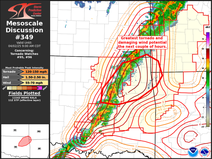
   Mesoscale Discussion 0349
   NWS Storm Prediction Center Norman OK
   0657 AM CDT Wed Apr 02 2025

   Areas affected...northeast OK into extreme southwest MO/northwest AR

   Concerning...Tornado Watch 95...96...

   Valid 021157Z - 021400Z

   The severe weather threat for Tornado Watch 95, 96 continues.

   SUMMARY...Damaging wind and tornado potential may be maximized
   across northeast Oklahoma into extreme southwest Missouri/northwest
   Arkansas over the next couple of hours.

   DISCUSSION...Recent radar trends have shows some propensity for
   linear convection to become more supercellular. This activity is
   moving across the max STP corridor (effective layer STP around 5-7)
   amid strong vertical shear and moderate instability. While some
   rotation has been occurring, and even a brief TDS was noted over
   Tulsa and Rogers Counties in northeast OK, capping and storm motion
   parallel to the surface front is likely limiting the longevity of
   stronger/better organized cells within the broader line of
   convection. Nevertheless, a couple of tornadoes, damaging gusts and
   isolated large hail remain possible this morning.

   ..Leitman.. 04/02/2025

   ...Please see www.spc.noaa.gov for graphic product...

   ATTN...WFO...SGF...TSA...OUN...

   LAT...LON   36889542 37099478 36869430 36399415 36069438 35629512
               35449595 35509663 35979656 36809577 36889542

   MOST PROBABLE PEAK TORNADO INTENSITY...120-150 MPH
   MOST PROBABLE PEAK WIND GUST...55-70 MPH
   MOST PROBABLE PEAK HAIL SIZE...1.50-2.50 IN
|
|
Top/All Mesoscale Discussions/Forecast Products/Home
|
|


 @NWSSPC