|
| Mesoscale Discussion 431 |
|
< Previous MD Next MD >
|
|
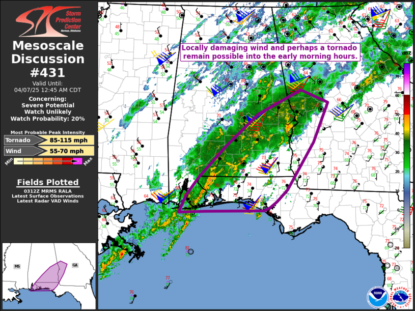
   Mesoscale Discussion 0431
   NWS Storm Prediction Center Norman OK
   1014 PM CDT Sun Apr 06 2025

   Areas affected...Southeast AL...FL Panhandle...southwest GA

   Concerning...Severe potential...Watch unlikely

   Valid 070314Z - 070545Z

   Probability of Watch Issuance...20 percent

   SUMMARY...Locally damaging wind and perhaps a tornado remain
   possible into the early morning hours.

   DISCUSSION...Widespread convection is ongoing late this evening
   across parts of south AL into the western FL Panhandle, in response
   to an approaching mid/upper-level trough, and a persistent
   southwesterly low-level jet.

   Several small cells with occasional weak rotation have been noted
   across southeast AL. These cells may continue to develop within the
   low-level warm advection regime. Modest MLCAPE and weak midlevel
   lapse rates will tend to limit updraft strength, but rich
   boundary-layer moisture and favorable wind profiles (as noted on
   regional VWPs) will support potential for at least transient
   supercells, which may be accompanied by the threat of a tornado
   and/or isolated strong gusts.

   Farther west, multiple loosely organized clusters have occasionally
   emerged from regenerative convection near/east of Mobile. Some
   threat for locally damaging wind and a tornado could develop if any
   of these clusters can become more organized and sustained as they
   spread northeastward with time.

   Watch issuance continues to be considered unlikely, due to the
   expectation that the severe threat will remain rather isolated, but
   trends will continue to be monitored for an uptick in coverage of
   organizing storms.

   ..Dean/Hart.. 04/07/2025

   ...Please see www.spc.noaa.gov for graphic product...

   ATTN...WFO...FFC...TAE...BMX...MOB...

   LAT...LON   30208582 30188740 30148813 30548794 30988760 31728685
               32478598 33038479 32738405 31798446 30698519 30418548
               30278566 30208582

   MOST PROBABLE PEAK TORNADO INTENSITY...85-115 MPH
   MOST PROBABLE PEAK WIND GUST...55-70 MPH
|
|
Top/All Mesoscale Discussions/Forecast Products/Home
|
|


 @NWSSPC