|
| Mesoscale Discussion 436 |
|
< Previous MD Next MD >
|
|
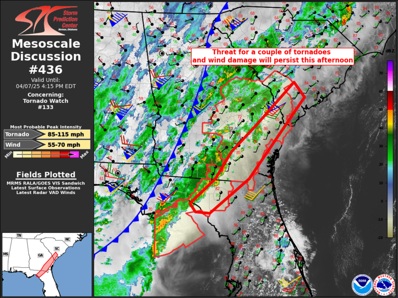
   Mesoscale Discussion 0436
   NWS Storm Prediction Center Norman OK
   0139 PM CDT Mon Apr 07 2025

   Areas affected...Northeast Florida...southeast Georgia and southern
   South Carolina

   Concerning...Tornado Watch 133...

   Valid 071839Z - 072015Z

   The severe weather threat for Tornado Watch 133 continues.

   SUMMARY...A couple of tornadoes and occasional wind damage will be
   possible through the afternoon.

   DISCUSSION...A pre-frontal band of convection continues to shift
   eastward this afternoon on weak convective outflow, as the storms
   spread into an environment where surface temperatures have warmed
   into the low-mid 80s with 64-70 F dewpoints.  Wind profiles have
   become more unidirectional/southwesterly with time, and forcing for
   ascent is relatively modest well downstream from the positive-tilt
   midlevel trough over the lower MS Valley.  The overall severe threat
   appears to be transitioning more to occasional wind damage with
   short bowing segments, though a couple of tornadoes will still be
   possible.

   ..Thompson.. 04/07/2025

   ...Please see www.spc.noaa.gov for graphic product...

   ATTN...WFO...CHS...CAE...JAX...TAE...

   LAT...LON   29748334 29788378 29998394 30668319 31378271 32068195
               33198077 32798045 30668216 29748334

   MOST PROBABLE PEAK TORNADO INTENSITY...85-115 MPH
   MOST PROBABLE PEAK WIND GUST...55-70 MPH
|
|
Top/All Mesoscale Discussions/Forecast Products/Home
|
|


 @NWSSPC