|
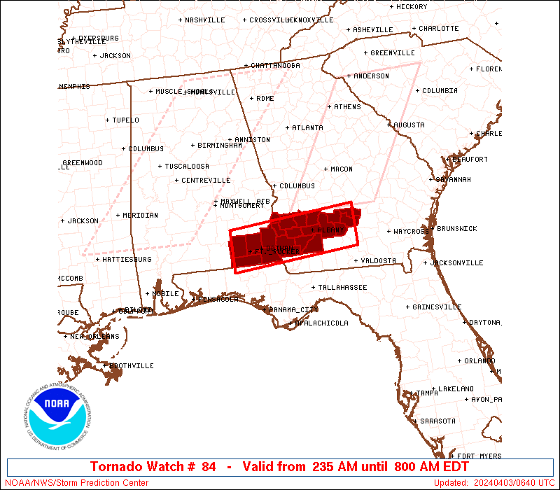
Initial List of Counties in SPC Tornado Watch 84 (WOU)
|
Back to Watch 84
|
 |
   WOUS64 KWNS 030632
   WOU4

   BULLETIN - IMMEDIATE BROADCAST REQUESTED
   TORNADO WATCH OUTLINE UPDATE FOR WT 84
   NWS STORM PREDICTION CENTER NORMAN OK
   235 AM EDT WED APR 3 2024

   TORNADO WATCH 84 IS IN EFFECT UNTIL 800 AM EDT FOR THE
    FOLLOWING LOCATIONS

   ALC031-045-061-067-069-031200-
   /O.NEW.KWNS.TO.A.0084.240403T0635Z-240403T1200Z/

   AL
   .    ALABAMA COUNTIES INCLUDED ARE

   COFFEE               DALE                GENEVA
   HENRY                HOUSTON


   GAC007-017-037-061-095-099-155-177-201-205-239-243-273-277-287-
   321-031200-
   /O.NEW.KWNS.TO.A.0084.240403T0635Z-240403T1200Z/

   GA
   .    GEORGIA COUNTIES INCLUDED ARE

   BAKER                BEN HILL            CALHOUN
   CLAY                 DOUGHERTY           EARLY
   IRWIN                LEE                 MILLER
   MITCHELL             QUITMAN             RANDOLPH
   TERRELL              TIFT                TURNER
   WORTH


   ATTN...WFO...TAE...
|
| Aviation Watch (SAW) for WW84 |
|---|
 |
| Note:
The Aviation Watch (SAW) product is an approximation to the watch area.
The actual watch is depicted by the shaded areas. |
   SAW4
   WW 84 TORNADO AL GA 030635Z - 031200Z
   AXIS..30 STATUTE MILES NORTH AND SOUTH OF LINE..
   40W DHN/DOTHAN AL/ - 60E ABY/ALBANY GA/
   ..AVIATION COORDS.. 25NM N/S /41NE CEW - 34W AMG/
   HAIL SURFACE AND ALOFT..1.5 INCHES. WIND GUSTS..60 KNOTS.
   MAX TOPS TO 500. MEAN STORM MOTION VECTOR 25050.

   LAT...LON 31758613 31968318 31098318 30888613

   THIS IS AN APPROXIMATION TO THE WATCH AREA.  FOR A
   COMPLETE DEPICTION OF THE WATCH SEE WOUS64 KWNS
   FOR WOU4.
|
|


 @NWSSPC