|
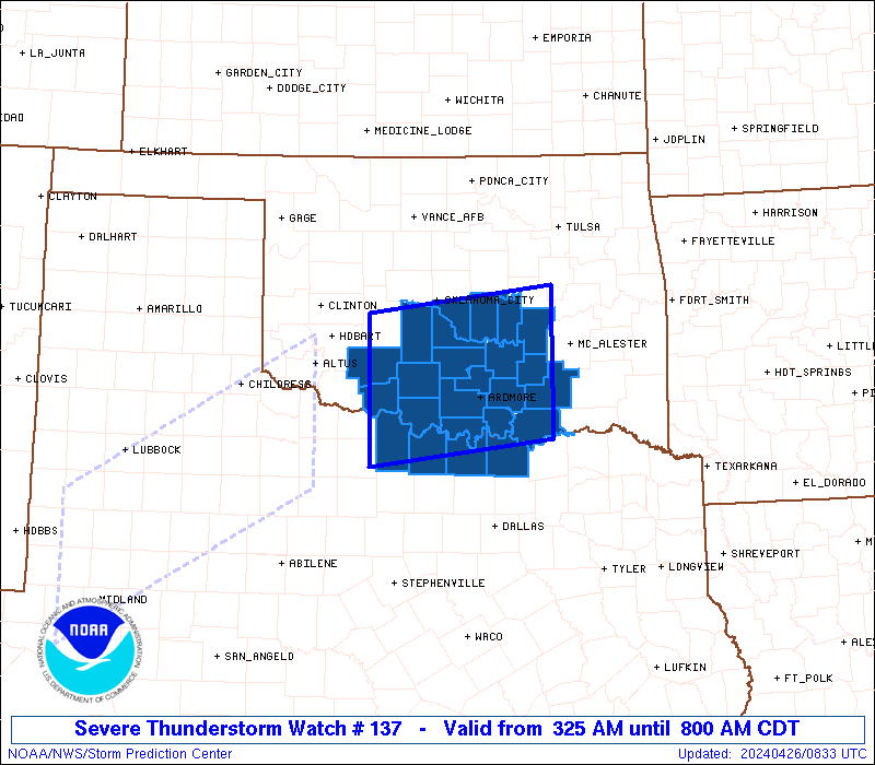
Initial List of Counties in SPC Severe Thunderstorm Watch 137 (WOU)
|
Back to Watch 137
|
 |
   WOUS64 KWNS 260825
   WOU7

   BULLETIN - IMMEDIATE BROADCAST REQUESTED
   SEVERE THUNDERSTORM WATCH OUTLINE UPDATE FOR WS 137
   NWS STORM PREDICTION CENTER NORMAN OK
   325 AM CDT FRI APR 26 2024

   SEVERE THUNDERSTORM WATCH 137 IS IN EFFECT UNTIL 800 AM CDT
   FOR THE FOLLOWING LOCATIONS

   OKC005-013-019-027-029-031-033-049-051-063-067-069-085-087-095-
   099-123-125-133-137-261300-
   /O.NEW.KWNS.SV.A.0137.240426T0825Z-240426T1300Z/

   OK
   .    OKLAHOMA COUNTIES INCLUDED ARE

   ATOKA                BRYAN               CARTER
   CLEVELAND            COAL                COMANCHE
   COTTON               GARVIN              GRADY
   HUGHES               JEFFERSON           JOHNSTON
   LOVE                 MARSHALL            MCCLAIN
   MURRAY               PONTOTOC            POTTAWATOMIE
   SEMINOLE             STEPHENS


   TXC077-097-181-337-261300-
   /O.NEW.KWNS.SV.A.0137.240426T0825Z-240426T1300Z/

   TX
   .    TEXAS COUNTIES INCLUDED ARE

   CLAY                 COOKE               GRAYSON
   MONTAGUE


   ATTN...WFO...OUN...FWD...
|
| Aviation Watch (SAW) for WW137 |
|---|
 |
| Note:
The Aviation Watch (SAW) product is an approximation to the watch area.
The actual watch is depicted by the shaded areas. |
   SAW7
   WW 137 SEVERE TSTM OK TX 260825Z - 261300Z
   AXIS..60 STATUTE MILES NORTH AND SOUTH OF LINE..
   20SSW FSI/FORT SILL OK/ - 55NNE DUA/DURANT OK/
   ..AVIATION COORDS.. 50NM N/S /24N SPS - 16SW MLC/
   HAIL SURFACE AND ALOFT..1.5 INCHES. WIND GUSTS..60 KNOTS.
   MAX TOPS TO 500. MEAN STORM MOTION VECTOR 25040.

   LAT...LON 35259853 35559603 33829603 33509853

   THIS IS AN APPROXIMATION TO THE WATCH AREA.  FOR A
   COMPLETE DEPICTION OF THE WATCH SEE WOUS64 KWNS
   FOR WOU7.
|
|


 @NWSSPC