|
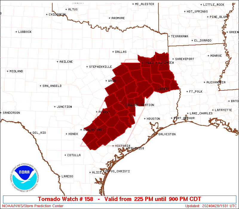
Initial List of Counties in SPC Tornado Watch 158 (WOU)
|
Back to Watch 158
|
 |
   WOUS64 KWNS 281924
   WOU8

   BULLETIN - IMMEDIATE BROADCAST REQUESTED
   TORNADO WATCH OUTLINE UPDATE FOR WT 158
   NWS STORM PREDICTION CENTER NORMAN OK
   225 PM CDT SUN APR 28 2024

   TORNADO WATCH 158 IS IN EFFECT UNTIL 900 PM CDT FOR THE
    FOLLOWING LOCATIONS

   TXC001-005-015-021-041-051-055-073-089-123-145-149-161-177-183-
   185-187-203-213-225-255-285-287-289-293-313-331-347-349-365-395-
   401-403-405-419-423-455-471-473-477-493-290200-
   /O.NEW.KWNS.TO.A.0158.240428T1925Z-240429T0200Z/

   TX
   .    TEXAS COUNTIES INCLUDED ARE

   ANDERSON             ANGELINA            AUSTIN
   BASTROP              BRAZOS              BURLESON
   CALDWELL             CHEROKEE            COLORADO
   DEWITT               FALLS               FAYETTE
   FREESTONE            GONZALES            GREGG
   GRIMES               GUADALUPE           HARRISON
   HENDERSON            HOUSTON             KARNES
   LAVACA               LEE                 LEON
   LIMESTONE            MADISON             MILAM
   NACOGDOCHES          NAVARRO             PANOLA
   ROBERTSON            RUSK                SABINE
   SAN AUGUSTINE        SHELBY              SMITH
   TRINITY              WALKER              WALLER
   WASHINGTON           WILSON


   ATTN...WFO...FWD...EWX...HGX...SHV...
|
| Aviation Watch (SAW) for WW158 |
|---|
 |
| Note:
The Aviation Watch (SAW) product is an approximation to the watch area.
The actual watch is depicted by the shaded areas. |
   SAW8
   WW 158 TORNADO TX 281925Z - 290200Z
   AXIS..65 STATUTE MILES EAST AND WEST OF LINE..
   30W VCT/VICTORIA TX/ - 25WNW GGG/LONGVIEW TX/
   ..AVIATION COORDS.. 55NM E/W /57N CRP - 19WNW GGG/
   HAIL SURFACE AND ALOFT..2 INCHES. WIND GUSTS..60 KNOTS.
   MAX TOPS TO 500. MEAN STORM MOTION VECTOR 25035.

   LAT...LON 28849849 32509623 32509400 28849634

   THIS IS AN APPROXIMATION TO THE WATCH AREA.  FOR A
   COMPLETE DEPICTION OF THE WATCH SEE WOUS64 KWNS
   FOR WOU8.
|
|


 @NWSSPC