|
Initial List of Counties in SPC Tornado Watch 205 (WOU)
|
Back to Watch 205
|
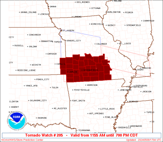 |
   WOUS64 KWNS 081656
   WOU5

   BULLETIN - IMMEDIATE BROADCAST REQUESTED
   TORNADO WATCH OUTLINE UPDATE FOR WT 205
   NWS STORM PREDICTION CENTER NORMAN OK
   1155 AM CDT WED MAY 8 2024

   TORNADO WATCH 205 IS IN EFFECT UNTIL 700 PM CDT FOR THE
    FOLLOWING LOCATIONS

   KSC011-021-037-090000-
   /O.NEW.KWNS.TO.A.0205.240508T1655Z-240509T0000Z/

   KS
   .    KANSAS COUNTIES INCLUDED ARE

   BOURBON              CHEROKEE            CRAWFORD


   MOC009-011-029-039-043-057-059-065-067-077-085-091-097-105-109-
   119-145-149-153-161-167-169-185-203-209-213-215-217-225-229-
   090000-
   /O.NEW.KWNS.TO.A.0205.240508T1655Z-240509T0000Z/

   MO
   .    MISSOURI COUNTIES INCLUDED ARE

   BARRY                BARTON              CAMDEN
   CEDAR                CHRISTIAN           DADE
   DALLAS               DENT                DOUGLAS
   GREENE               HICKORY             HOWELL
   JASPER               LACLEDE             LAWRENCE
   MCDONALD             NEWTON              OREGON
   OZARK                PHELPS              POLK
   PULASKI              SHANNON             ST. CLAIR
   STONE                TANEY               TEXAS
   VERNON               WEBSTER             WRIGHT


   ATTN...WFO...SGF...
|
| Aviation Watch (SAW) for WW205 |
|---|
 |
| Note:
The Aviation Watch (SAW) product is an approximation to the watch area.
The actual watch is depicted by the shaded areas. |
   SAW5
   WW 205 TORNADO KS MO 081655Z - 090000Z
   AXIS..50 STATUTE MILES NORTH AND SOUTH OF LINE..
   20WNW JLN/JOPLIN MO/ - 45NE UNO/WEST PLAINS MO/
   ..AVIATION COORDS.. 45NM N/S /19ENE OSW - 58WSW FAM/
   HAIL SURFACE AND ALOFT..3 INCHES. WIND GUSTS..65 KNOTS.
   MAX TOPS TO 550. MEAN STORM MOTION VECTOR 27030.

   LAT...LON 37989484 37939129 36499129 36549484

   THIS IS AN APPROXIMATION TO THE WATCH AREA.  FOR A
   COMPLETE DEPICTION OF THE WATCH SEE WOUS64 KWNS
   FOR WOU5.
|
|


 @NWSSPC
