|
Initial List of Counties in SPC Tornado Watch 319 (WOU)
|
Back to Watch 319
|
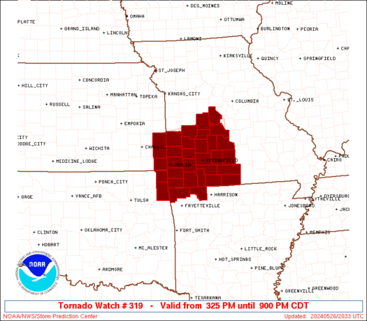 |
   WOUS64 KWNS 262025
   WOU9

   BULLETIN - IMMEDIATE BROADCAST REQUESTED
   TORNADO WATCH OUTLINE UPDATE FOR WT 319
   NWS STORM PREDICTION CENTER NORMAN OK
   325 PM CDT SUN MAY 26 2024

   TORNADO WATCH 319 IS IN EFFECT UNTIL 900 PM CDT FOR THE
    FOLLOWING LOCATIONS

   ARC007-015-270200-
   /O.NEW.KWNS.TO.A.0319.240526T2025Z-240527T0200Z/

   AR
   .    ARKANSAS COUNTIES INCLUDED ARE

   BENTON               CARROLL


   KSC011-021-037-270200-
   /O.NEW.KWNS.TO.A.0319.240526T2025Z-240527T0200Z/

   KS
   .    KANSAS COUNTIES INCLUDED ARE

   BOURBON              CHEROKEE            CRAWFORD


   MOC009-011-015-029-039-043-057-059-067-077-085-097-105-109-119-
   141-145-153-167-185-209-213-217-225-229-270200-
   /O.NEW.KWNS.TO.A.0319.240526T2025Z-240527T0200Z/

   MO
   .    MISSOURI COUNTIES INCLUDED ARE

   BARRY                BARTON              BENTON
   CAMDEN               CEDAR               CHRISTIAN
   DADE                 DALLAS              DOUGLAS
   GREENE               HICKORY             JASPER
   LACLEDE              LAWRENCE            MCDONALD
   MORGAN               NEWTON              OZARK
   POLK                 ST. CLAIR           STONE
   TANEY                VERNON              WEBSTER
   WRIGHT


   OKC041-115-270200-
   /O.NEW.KWNS.TO.A.0319.240526T2025Z-240527T0200Z/

   OK
   .    OKLAHOMA COUNTIES INCLUDED ARE

   DELAWARE             OTTAWA


   ATTN...WFO...TSA...SGF...
|
| Aviation Watch (SAW) for WW319 |
|---|
 |
| Note:
The Aviation Watch (SAW) product is an approximation to the watch area.
The actual watch is depicted by the shaded areas. |
   SAW9
   WW 319 TORNADO AR KS MO OK 262025Z - 270200Z
   AXIS..60 STATUTE MILES NORTH AND SOUTH OF LINE..
   20W JLN/JOPLIN MO/ - 50ENE SGF/SPRINGFIELD MO/
   ..AVIATION COORDS.. 50NM N/S /16E OSW - 39ENE SGF/
   HAIL SURFACE AND ALOFT..2.5 INCHES. WIND GUSTS..60 KNOTS.
   MAX TOPS TO 600. MEAN STORM MOTION VECTOR 27030.

   LAT...LON 38029486 38369254 36639254 36289486

   THIS IS AN APPROXIMATION TO THE WATCH AREA.  FOR A
   COMPLETE DEPICTION OF THE WATCH SEE WOUS64 KWNS
   FOR WOU9.
|
|


 @NWSSPC
