|
Initial List of Counties in SPC Severe Thunderstorm Watch 468 (WOU)
|
Back to Watch 468
|
 |
WOUS64 KWNS 262143
WOU8
BULLETIN - IMMEDIATE BROADCAST REQUESTED
SEVERE THUNDERSTORM WATCH OUTLINE UPDATE FOR WS 468
NWS STORM PREDICTION CENTER NORMAN OK
345 PM MDT WED JUN 26 2024
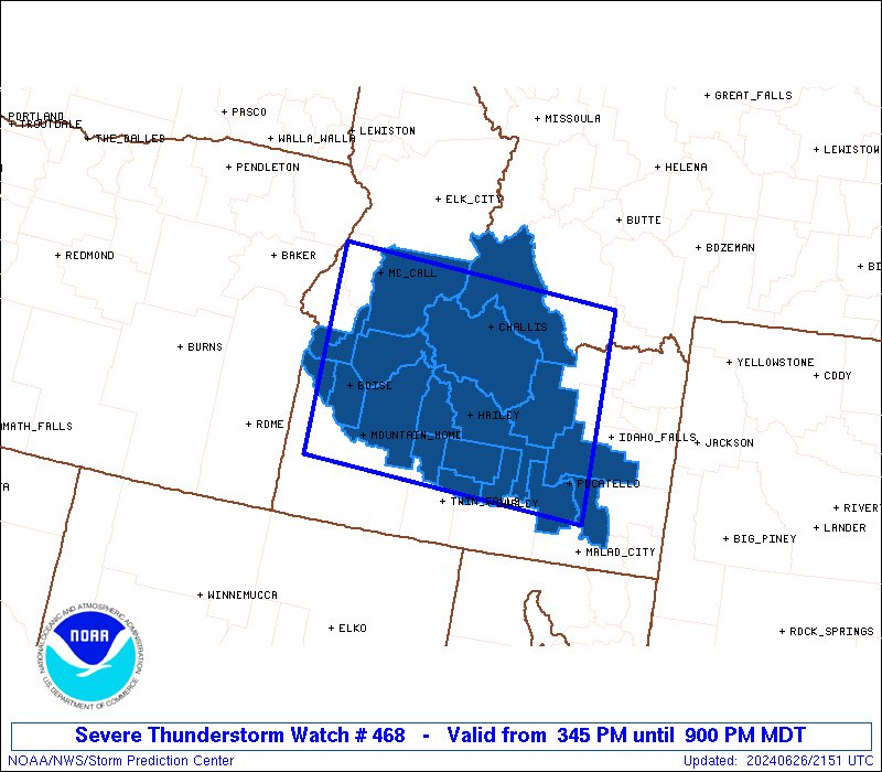
SEVERE THUNDERSTORM WATCH 468 IS IN EFFECT UNTIL 900 PM MDT
FOR THE FOLLOWING LOCATIONS
IDC001-005-011-013-015-023-025-027-037-039-045-047-053-059-063-
067-075-077-085-270300-
/O.NEW.KWNS.SV.A.0468.240626T2145Z-240627T0300Z/
ID
. IDAHO COUNTIES INCLUDED ARE
ADA BANNOCK BINGHAM
BLAINE BOISE BUTTE
CAMAS CANYON CUSTER
ELMORE GEM GOODING
JEROME LEMHI LINCOLN
MINIDOKA PAYETTE POWER
VALLEY
ATTN...WFO...BOI...PIH...MSO...
|
| Aviation Watch (SAW) for WW468 |
|---|
 |
| Note:
The Aviation Watch (SAW) product is an approximation to the watch area.
The actual watch is depicted by the shaded areas. |
   SAW8
   WW 468 SEVERE TSTM ID 262145Z - 270300Z
   AXIS..85 STATUTE MILES NORTH AND SOUTH OF LINE..
   35NW BOI/BOISE ID/ - 60S MQM/MONIDA MT/
   ..AVIATION COORDS.. 75NM N/S /32NW BOI - 24SSW DBS/
   HAIL SURFACE AND ALOFT..1.5 INCHES. WIND GUSTS..60 KNOTS.
   MAX TOPS TO 400. MEAN STORM MOTION VECTOR 25025.

   LAT...LON 45161672 44931232 42471232 42701672

   THIS IS AN APPROXIMATION TO THE WATCH AREA.  FOR A
   COMPLETE DEPICTION OF THE WATCH SEE WOUS64 KWNS
   FOR WOU8.
|
|


 @NWSSPC