|
Initial List of Counties in SPC Tornado Watch 496 (WOU)
|
Back to Watch 496
|
 |
WOUS64 KWNS 012055
WOU6
BULLETIN - IMMEDIATE BROADCAST REQUESTED
TORNADO WATCH OUTLINE UPDATE FOR WT 496
NWS STORM PREDICTION CENTER NORMAN OK
355 PM CDT MON JUL 1 2024
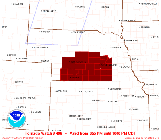
TORNADO WATCH 496 IS IN EFFECT UNTIL 1000 PM CDT FOR THE
FOLLOWING LOCATIONS
NEC001-019-035-041-047-059-061-063-065-073-077-079-081-083-085-
087-093-099-111-121-125-129-137-143-145-163-169-175-181-185-
020300-
/O.NEW.KWNS.TO.A.0496.240701T2055Z-240702T0300Z/
NE
. NEBRASKA COUNTIES INCLUDED ARE
ADAMS BUFFALO CLAY
CUSTER DAWSON FILLMORE
FRANKLIN FRONTIER FURNAS
GOSPER GREELEY HALL
HAMILTON HARLAN HAYES
HITCHCOCK HOWARD KEARNEY
LINCOLN MERRICK NANCE
NUCKOLLS PHELPS POLK
RED WILLOW SHERMAN THAYER
VALLEY WEBSTER YORK
ATTN...WFO...GID...GLD...LBF...
|
| Aviation Watch (SAW) for WW496 |
|---|
 |
| Note:
The Aviation Watch (SAW) product is an approximation to the watch area.
The actual watch is depicted by the shaded areas. |
   SAW6
   WW 496 TORNADO NE 012055Z - 020300Z
   AXIS..45 STATUTE MILES NORTH AND SOUTH OF LINE..
   40NW MCK/MCCOOK NE/ - 30ESE GRI/GRAND ISLAND NE/
   ..AVIATION COORDS.. 40NM N/S /34NW MCK - 43SE OBH/
   HAIL SURFACE AND ALOFT..2 INCHES. WIND GUSTS..65 KNOTS.
   MAX TOPS TO 500. MEAN STORM MOTION VECTOR 26035.

   LAT...LON 41260112 41459779 40159779 39960112

   THIS IS AN APPROXIMATION TO THE WATCH AREA.  FOR A
   COMPLETE DEPICTION OF THE WATCH SEE WOUS64 KWNS
   FOR WOU6.
|
|


 @NWSSPC
