|
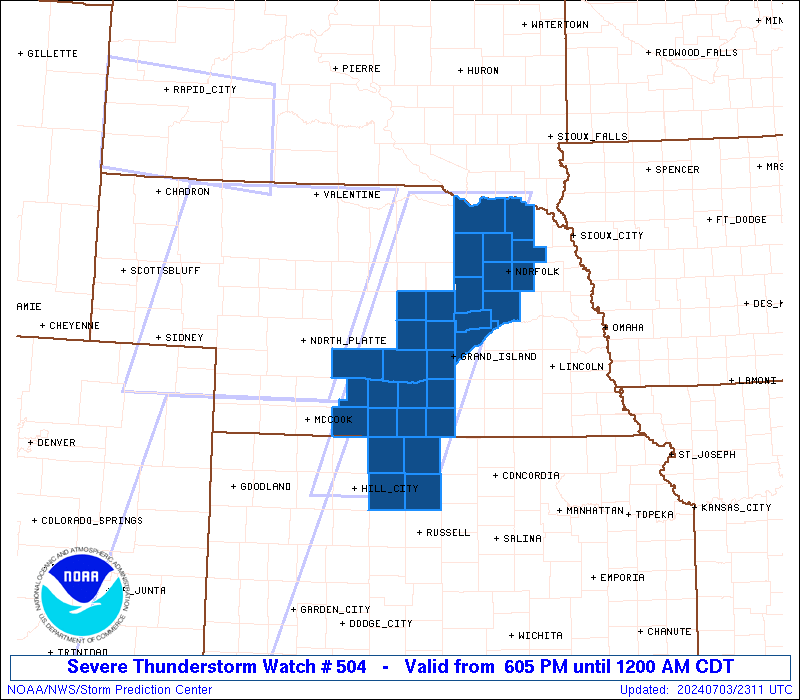
Initial List of Counties in SPC Severe Thunderstorm Watch 504 (WOU)
|
Back to Watch 504
|
 |
   WOUS64 KWNS 032303
   WOU4

   BULLETIN - IMMEDIATE BROADCAST REQUESTED
   SEVERE THUNDERSTORM WATCH OUTLINE UPDATE FOR WS 504
   NWS STORM PREDICTION CENTER NORMAN OK
   605 PM CDT WED JUL 3 2024

   SEVERE THUNDERSTORM WATCH 504 IS IN EFFECT UNTIL 1200 AM CDT
   FOR THE FOLLOWING LOCATIONS

   KSC141-147-163-183-040500-
   /O.NEW.KWNS.SV.A.0504.240703T2305Z-240704T0500Z/

   KS
   .    KANSAS COUNTIES INCLUDED ARE

   OSBORNE              PHILLIPS            ROOKS
   SMITH


   NEC001-003-011-019-027-047-061-065-073-077-079-083-093-099-107-
   119-121-125-137-139-141-163-167-175-179-181-040500-
   /O.NEW.KWNS.SV.A.0504.240703T2305Z-240704T0500Z/

   NE
   .    NEBRASKA COUNTIES INCLUDED ARE

   ADAMS                ANTELOPE            BOONE
   BUFFALO              CEDAR               DAWSON
   FRANKLIN             FURNAS              GOSPER
   GREELEY              HALL                HARLAN
   HOWARD               KEARNEY             KNOX
   MADISON              MERRICK             NANCE
   PHELPS               PIERCE              PLATTE
   SHERMAN              STANTON             VALLEY
   WAYNE                WEBSTER


   ATTN...WFO...GID...OAX...
|
| Aviation Watch (SAW) for WW504 |
|---|
 |
| Note:
The Aviation Watch (SAW) product is an approximation to the watch area.
The actual watch is depicted by the shaded areas. |
   SAW4
   WW 504 SEVERE TSTM KS NE 032305Z - 040500Z
   AXIS..50 STATUTE MILES EAST AND WEST OF LINE..
   45NE ONL/ONEILL NE/ - 15ESE HLC/HILL CITY KS/
   ..AVIATION COORDS.. 45NM E/W /39NE ONL - 31E HLC/
   HAIL SURFACE AND ALOFT..1.5 INCHES. WIND GUSTS..60 KNOTS.
   MAX TOPS TO 500. MEAN STORM MOTION VECTOR 27030.

   LAT...LON 42929706 39299864 39290051 42929904

   THIS IS AN APPROXIMATION TO THE WATCH AREA.  FOR A
   COMPLETE DEPICTION OF THE WATCH SEE WOUS64 KWNS
   FOR WOU4.
|
|


 @NWSSPC