|
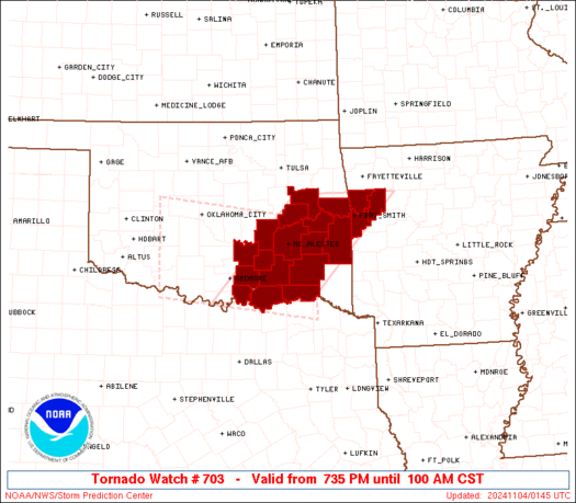
Initial List of Counties in SPC Tornado Watch 703 (WOU)
|
Back to Watch 703
|
 |
   WOUS64 KWNS 040137
   WOU3

   BULLETIN - IMMEDIATE BROADCAST REQUESTED
   TORNADO WATCH OUTLINE UPDATE FOR WT 703
   NWS STORM PREDICTION CENTER NORMAN OK
   735 PM CST SUN NOV 3 2024

   TORNADO WATCH 703 IS IN EFFECT UNTIL 100 AM CST FOR THE
    FOLLOWING LOCATIONS

   ARC033-047-131-040700-
   /O.NEW.KWNS.TO.A.0703.241104T0135Z-241104T0700Z/

   AR
   .    ARKANSAS COUNTIES INCLUDED ARE

   CRAWFORD             FRANKLIN            SEBASTIAN


   OKC005-013-023-029-061-063-069-077-079-091-095-101-121-123-127-
   135-040700-
   /O.NEW.KWNS.TO.A.0703.241104T0135Z-241104T0700Z/

   OK
   .    OKLAHOMA COUNTIES INCLUDED ARE

   ATOKA                BRYAN               CHOCTAW
   COAL                 HASKELL             HUGHES
   JOHNSTON             LATIMER             LE FLORE
   MARSHALL             MCINTOSH            MUSKOGEE
   PITTSBURG            PONTOTOC            PUSHMATAHA
   SEQUOYAH


   ATTN...WFO...TSA...OUN...
|
| Aviation Watch (SAW) for WW703 |
|---|
 |
| Note:
The Aviation Watch (SAW) product is an approximation to the watch area.
The actual watch is depicted by the shaded areas. |
   SAW3
   WW 703 TORNADO AR OK 040135Z - 040700Z
   AXIS..60 STATUTE MILES EAST AND WEST OF LINE..
   30NNW FSM/FORT SMITH AR/ - 5SSE DUA/DURANT OK/
   ..AVIATION COORDS.. 50NM E/W /26NW FSM - 45ESE ADM/
   HAIL SURFACE AND ALOFT..1.5 INCHES. WIND GUSTS..60 KNOTS.
   MAX TOPS TO 500. MEAN STORM MOTION VECTOR 24035.

   LAT...LON 35739351 33889532 33889741 35739564

   THIS IS AN APPROXIMATION TO THE WATCH AREA.  FOR A
   COMPLETE DEPICTION OF THE WATCH SEE WOUS64 KWNS
   FOR WOU3.
|
|


 @NWSSPC
