Day 3-8 Fire Weather Outlook Issued on May 18, 2024
Updated: Sat May 18 20:52:03 UTC 2024 (Print Version)
Note: Fire weather probabilistic information in
MS-Word or
PDF. Note: On February 23, 2021 the Probabilistic Day 3-8 Fire Weather Outlooks became operational. Please see the Service Change Notice 20-115 for more details.
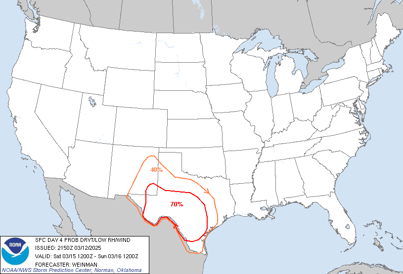
El Paso, TX...Las Cruces, NM...Alamogordo, NM...Socorro, TX...Deming, NM...
D3
Mon, May 20, 2024 - Tue, May 21, 2024
D6
Thu, May 23, 2024 - Fri, May 24, 2024
D4
Tue, May 21, 2024 - Wed, May 22, 2024
D7
Fri, May 24, 2024 - Sat, May 25, 2024
D5
Wed, May 22, 2024 - Thu, May 23, 2024
D8
Sat, May 25, 2024 - Sun, May 26, 2024
(All days are valid from 12 UTC - 12 UTC)
   ZCZC SPCFWDD38 ALL
   FNUS28 KWNS 182047

   Day 3-8 Fire Weather Outlook
   NWS Storm Prediction Center Norman OK
   0347 PM CDT Sat May 18 2024

   Valid 201200Z - 261200Z

   A persistent mean mid/upper-level trough is forecast across the
   western United States from Day 3/Monday through at least Day
   8/Saturday. This will promote a multi-day period of enhanced
   mid-level west to southwesterly flow across the Southwest and a
   prolonged period of dry/breezy surface conditions. While the latest
   fuel guidance suggests fuels across much of this region are only
   marginal receptive, owing in part to recent precipitation, several
   days of additional curing over the next few days and into next week
   will likely allow fuels to become critically dry.

   ...Day 3/Monday...
   Meteorologically, fire weather conditions may peak on Day 3/Monday
   as a strong mid-level jet overspreads the Southwest. Widespread
   critical RH values are expected with strong/gusty surface winds.
   While Critical fire weather conditions are possible across a rather
   broad area, primary uncertainty remains the impact of recent
   rainfall on fuels across portions of central/eastern New Mexico and
   the general state of fuels across Arizona.

   Have introduced 70% probabilities for Critical Fire weather
   conditions where confidence in critical conditions is greatest owing
   to less recent rainfall. The Critical area may need to be
   refined/expanded as fuel guidance is updated. Additionally, while a
   few isolated dry thunderstorms are possible (mainly across portions
   of Arizona), confidence is currently too low to introduce
   probabilities.

   ...Day 4/Tuesday...
   Mid-level flow will shift eastward into the Plains by Day 4/Tuesday
   with the rear portion of the enhanced mid-level flow remaining over
   portions of New Mexico and Arizona. Near critical fire weather
   conditions appear likely, as dry air and breezy surface winds
   overlap increasingly dry fuels. While Critical fire weather
   conditions are possible, uncertainty regarding fuel recovery after
   recent rainfall across much of central New Mexico precludes
   increasing the critical probabilities.

   ...Day 5/Wednesday - Day 6/Thursday...
   Fire weather conditions may decrease some on Day 5/Wednesday and Day
   6/Thursday as the stronger mid-level flow moves out of the
   Southwest. Nevertheless, continued enhanced mid-level flow will
   promote Elevated to locally Critical fire weather conditions each
   day across portions of Arizona and New Mexico.

   ...Day 7/Friday - Day 8/Saturday...
   While exact details remain unclear this far in advance, ensemble
   guidance suggests that mid-level flow will strengthen again late
   this week and into next weekend across portions of the Southwest.
   This may lead to another prolonged period of Critical fire weather
   conditions over a broad area, especially as several days of
   dry/breezy conditions and no appreciable rainfall will likely lead
   to widespread Critically receptive fuels by then.

   ..Elliott.. 05/18/2024

   ...Please see www.spc.noaa.gov/fire for graphic product...

   $$

   CLICK TO GET FNUS38 KWNS PFWF38 FIRE WEATHER OUTLOOK DAY 3-8 AREAL OUTLINE PRODUCT


 @NWSSPC


