|
| Mesoscale Discussion 159 |
|
< Previous MD Next MD >
|

|
   Mesoscale Discussion 0159
   NWS Storm Prediction Center Norman OK
   0542 AM CST Tue Feb 27 2024

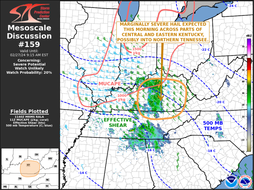
   Areas affected...Central and Eastern Kentucky...Northern Tennessee

   Concerning...Severe potential...Watch unlikely

   Valid 271142Z - 271415Z

   Probability of Watch Issuance...20 percent

   SUMMARY...A threat for marginally severe hail may develop over parts
   of central and eastern Kentucky this morning. The magnitude of the
   hail threat should remain too small for weather watch issuance.

   DISCUSSION...The latest water vapor imagery shows a patch of
   maximized mid-level moisture associated with a shortwave trough,
   located across the Ohio and Tennessee Valleys. Scattered
   thunderstorms are ongoing with this area ahead of the shortwave
   trough over far southern Indiana, central Kentucky and middle
   Tennessee. Mesoscale analysis in central Kentucky has MUCAPE
   approaching 1000 J/kg, with 700-500 mb lapse rates in the 7 to 7.5
   C/km range. In addition, RAP forecast soundings in central Kentucky
   have a steep temperature inversion from the surface to 850 mb, with
   effective shear near 50 knots. This suggests some potential for a
   couple elevated rotating storms capable of marginally severe hail.
   The threat should continue into the mid to late morning as scattered
   strong thunderstorms move eastward into eastern Kentucky.

   ..Broyles/Goss.. 02/27/2024

   ...Please see www.spc.noaa.gov for graphic product...

   ATTN...WFO...RLX...MRX...JKL...ILN...LMK...OHX...

   LAT...LON   37038276 36568302 36288350 36188420 36158519 36378584
               36848613 37508617 38078599 38438545 38508451 38398340
               38228295 37858265 37038276
|
|
Top/All Mesoscale Discussions/Forecast Products/Home
|
|


