|
| Mesoscale Discussion 182 |
|
< Previous MD Next MD >
|

|
   Mesoscale Discussion 0182
   NWS Storm Prediction Center Norman OK
   1126 AM CST Sat Mar 02 2024

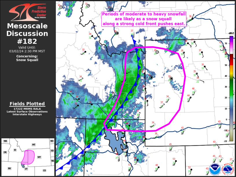
   Areas affected...Southeast Idaho into far northern Utah and western
   Wyoming

   Concerning...Snow Squall

   Valid 021726Z - 022130Z

   SUMMARY...A snow squall moving across southeast Idaho into western
   Wyoming and far northern Utah will bring periods of moderate to
   heavy snowfall rates and potentially near-blizzard conditions.

   DISCUSSION...Over the past 1-2 hours, a somewhat organized shallow
   convective band has developed along an eastward-pushing cold front
   across southeast ID into northwest UT. Although temperatures are
   currently hovering near or just above freezing over the region,
   surface observations have reported visibility reductions down to 1/4
   mile with the passage of the front, likely due to a combination of
   moderate to heavy snowfall rates as well as 35-45 mph wind gusts.
   Multiple lightning flashes have also been observed with the past 30
   minutes associated with a few of the deeper convective cores.

   The downstream environment appears supportive for maintenance, if
   not enhancement, of the convective band with SBCAPE values around
   250 J/kg noted in recent mesoanalyses with further destabilization
   up to around 500 J/kg possible by mid-afternoon across
   west/southwest WY. Furthermore, low-level lapse rates on the order
   of 8-9 C/km are noted across northern UT to central WY based on
   modified observed soundings and mesoanalysis fields. Dynamically,
   strong ascent within the left-exit region of the approach mid-level
   jet should continue to promote broadscale ascent favorable for
   further deepening of the attendant surface low, which should foster
   a strong frontal surge through the afternoon. The result will be a
   continuation of moderate to heavy snowfall rates and periods of
   near-blizzard conditions along and behind the snow squall/cold front
   for the next several hours.

   ..Moore.. 03/02/2024

   ...Please see www.spc.noaa.gov for graphic product...

   ATTN...WFO...RIW...TFX...SLC...PIH...

   LAT...LON   41831313 42431264 42911236 43561209 44261207 44521200
               44721158 44731064 44661006 44480931 44100909 43620896
               42910912 42370930 41840983 41571051 41551128 41601298
               41831313
|
|
Top/All Mesoscale Discussions/Forecast Products/Home
|
|


