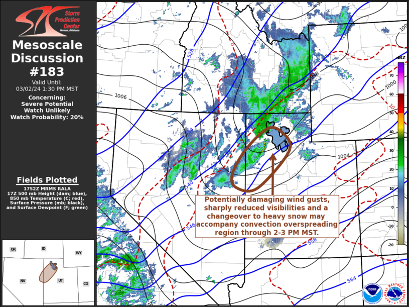
   Mesoscale Discussion 0183
   NWS Storm Prediction Center Norman OK
   1155 AM CST Sat Mar 02 2024

   Areas affected...the Great Salt Lake Desert into Wasatch vicinity

   Concerning...Severe potential...Watch unlikely

   Valid 021755Z - 022030Z

   Probability of Watch Issuance...20 percent

   SUMMARY...Thunderstorm activity may overspread the region, including
   much of the Salt Lake City area, through 2-3 PM MST, accompanied by
   potentially damaging surface gusts, small hail, sharply reduced
   visibilities and a changeover of precipitation to at least a brief
   period of heavy snow.

   DISCUSSION...Forecast soundings indicate thermodynamic profiles with
   largely sub-freezing temperatures and/or wet-bulb temperatures
   across the Great Salt Lake Desert into Wasatch vicinity, except for
   initially a shallow near-surface layer over lower elevations.  With
   insolation, a modestly deep and well-mixed boundary-layer appears to
   be evolving in advance of an approaching cold front, with sufficient
   moisture to support the development of weak boundary-layer based
   CAPE.  With continuing insolation, further cooling aloft will
   support additional destabilization through mid afternoon.

   Deepening pre-frontal convective development, some of which has
   begun to produce lightning, is already underway upstream in response
   to the destabilization, aided by forcing for ascent ahead of
   mid-level troughing overspreading much of the Great Basin and
   Northwest.  One northeastward progressing embedded short wave
   perturbation appears to passing near or to the northwest of the
   Great Salt Lake, with another trailing to its southwest.  It appears
   that associated forcing for ascent may be accompanied by a
   developing cluster of convection with embedded thunderstorms
   overspreading the Great Salt Lake Desert into Wasatch vicinity
   through 20-22Z.

   Beneath the exit region of a vigorous upper jet streak, Rapid
   Refresh and NAM output indicate strong mean flow on the order of
   45-50+ kt developing in the lowest few kilometers above
   ground-level, both ahead and to the rear of the convection.  Coupled
   with latent cooling in convective downdrafts, aided by melting small
   hail or graupel, downward mixing of momentum may promote strong to
   severe gusts reaching the surface.  This may also coincide with a
   precipitation changeover from rain and graupel to at least a brief
   period of heavy snow, contributing to sharply reduced visibilities
   as surface temperatures cool to near freezing.

   ..Kerr/Hart.. 03/02/2024

   ...Please see www.spc.noaa.gov for graphic product...

   ATTN...WFO...SLC...LKN...

   LAT...LON   40701408 41461309 41391244 40731205 39441349 39441442
               39871463 40701408
|


 @NWSSPC