|
| Mesoscale Discussion 235 |
|
< Previous MD Next MD >
|
|
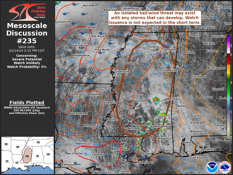
   Mesoscale Discussion 0235
   NWS Storm Prediction Center Norman OK
   0316 PM CDT Thu Mar 14 2024

   Areas affected...Portions of MS

   Concerning...Severe potential...Watch unlikely

   Valid 142016Z - 142215Z

   Probability of Watch Issuance...5 percent

   SUMMARY...An isolated hail/wind risk may exist with any
   thunderstorms that can develop. Watch issuance is not expected in
   the short term.

   DISCUSSION...A couple of thunderstorms have recently formed across
   southeast MS, on the eastern edge of the unstable warm sector across
   the lower MS Valley. Additional convective development appears
   possible over the next couple of hours across parts of central into
   northern MS where the cu field is gradually becoming more agitated
   in some locations. Large-scale forcing across this region remains
   fairly weak, but a weak southern-stream shortwave trough should
   continue to advance northeastward across LA/MS this afternoon, which
   may encourage additional development. Recent VWPs from KDGX/KGWX
   show weak low-level southerly flow gradually veering and
   strengthening with height through mid levels, with deep-layer shear
   generally 25-35 kt (stronger with northward extent in MS). This
   should be sufficient for modest updraft organization and possible
   clustering with time. Occasional strong to damaging winds of 50-60
   mph may occur with the more robust cores, and perhaps marginally
   severe hail. Given that the overall severe threat will likely remain
   quite isolated this afternoon, watch issuance is not expected in the
   short term.

   ..Gleason/Goss.. 03/14/2024

   ...Please see www.spc.noaa.gov for graphic product...

   ATTN...WFO...MOB...MEG...JAN...LIX...

   LAT...LON   32278855 31418886 31038952 31009019 31179075 32039093
               33419063 34339021 34668972 34678913 34348851 33708827
               32278855
|
|
Top/All Mesoscale Discussions/Forecast Products/Home
|
|


 @NWSSPC