|
| Mesoscale Discussion 236 |
|
< Previous MD Next MD >
|
|
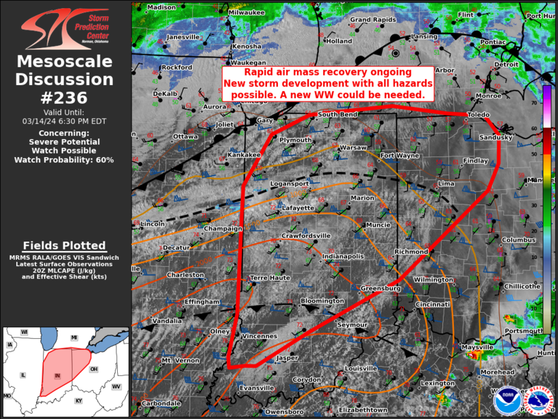
   Mesoscale Discussion 0236
   NWS Storm Prediction Center Norman OK
   0336 PM CDT Thu Mar 14 2024

   Areas affected...portions of Indiana and western Ohio and far
   southern Michigan

   Concerning...Severe potential...Watch possible

   Valid 142036Z - 142230Z

   Probability of Watch Issuance...60 percent

   SUMMARY...Afternoon satellite imagery shows rapid air mass recovery
   is ongoing across parts of IN and western OH. New storm development
   over north-central IL may expand eastward into IN and OH/MI, though
   this is uncertain. Supercells with all hazards are possible and a
   new WW is possible in the next couple of hours.

   DISCUSSION...Across parts of IN and OH the air mass in the wake of
   an early day MCS is rapidly recovering. With ample diurnal heating,
   surface temperatures have warmed into the low 70s F with surface
   dewpoints in the upper 50s to low 60s F. Several modified
   outflow/differential heating boundaries are present supporting ample
   mesoscale lift for storm initiation within the destabilizing air
   mass. SPC mesoanalysis shows 1000-1500 J/kg of MLCAPE has developed
   with 50-60 kt of effective shear. Storm organization (should
   development continue) into supercells or short bowing segments is
   probable. Mid-level lapse rates of 7-8 C and the strong vertical
   shear will favor large hail (especially with rotating updrafts),
   damaging gusts and a couple tornadoes.

   However, confidence in the development and the timing of robust
   storm development is modest given the air mass resides in the cold
   pool of the earlier MCS. Stable wave clouds and the relatively
   limited depth of boundary-layer CU are noted over much of IN, while
   more robust vertical development is confined to the differential
   heating axis/modified outflow. Forecaster experience suggests storms
   may struggle to become established initially with broad, albeit
   weak, synoptic decent likely ongoing behind the former MCS. Still,
   numerous CAM solutions and ongoing convection upstream over eastern
   MO and IL suggests storm development is possible. Stronger, more
   established convection over eastern MO may also move into
   southern/central IN later this afternoon/evening. Given the
   environment with expanding hodographs and favorable buoyancy this
   evening, these storms would pose a risk for all hazards.

   With confidence in the evolution in mind, convective trends are
   being monitored for a possible watch of portions of IN and western
   OH in the next couple of hours.

   ..Lyons/Goss.. 03/14/2024

   ...Please see www.spc.noaa.gov for graphic product...

   ATTN...WFO...CLE...ILN...DTX...LMK...IWX...IND...PAH...LOT...
   ILX...

   LAT...LON   38348725 38348746 38308772 38458773 39038760 40298756
               40768753 41478705 41748636 41868487 41758388 41718322
               41438297 41058298 40698319 39518477 38798636 38348725
|
|
Top/All Mesoscale Discussions/Forecast Products/Home
|
|


 @NWSSPC