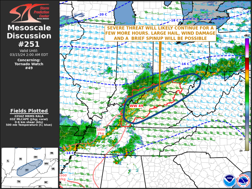
   Mesoscale Discussion 0251
   NWS Storm Prediction Center Norman OK
   1059 PM CDT Thu Mar 14 2024

   Areas affected...Far Southern Indiana...Kentucky...Southern
   Ohio...Far Western West Virginia

   Concerning...Tornado Watch 49...

   Valid 150359Z - 150600Z

   The severe weather threat for Tornado Watch 49 continues.

   SUMMARY...A severe threat will likely continue for a couple more
   hours across the Ohio Valley. Wind damage, isolated large hail, and
   perhaps a brief spinup will be possible.

   DISCUSSION...The latest mosaic radar imagery shows an mesoscale
   convective system over the Ohio Valley, with several embedded
   supercells and multiple short line segments. Weak instability is
   currently located to the south of the MCS across much of Kentucky.
   In spite of this, a 65 to 80 knot mid-level jet is analyzed over
   northern Indiana and northern Ohio. The MCS is currently located
   near the southern edge of the mid-level jet, where 0-6 km shear is
   estimated to be near 50 knots, according to the RAP. In addition, a
   40 knot low-level jet is analyzed over the Ohio Valley. The strong
   shear suggests that severe storms will continue to be possible over
   the next few hours. Wind damage, isolated large hail, and perhaps a
   brief tornado will be possible. However, the severe threat is
   expected to gradually decrease over time as the airmass gradually
   stabilizes.

   ..Broyles.. 03/15/2024

   ...Please see www.spc.noaa.gov for graphic product...

   ATTN...WFO...PBZ...RLX...JKL...ILN...LMK...

   LAT...LON   38738529 38158663 37438688 37078680 36878636 36898580
               37458441 38008312 38818155 39328128 39508136 39658167
               39648224 39238390 38738529
|


 @NWSSPC