|
| Mesoscale Discussion 317 |
|
< Previous MD Next MD >
|

|
   Mesoscale Discussion 0317
   NWS Storm Prediction Center Norman OK
   0526 PM CDT Sun Mar 31 2024

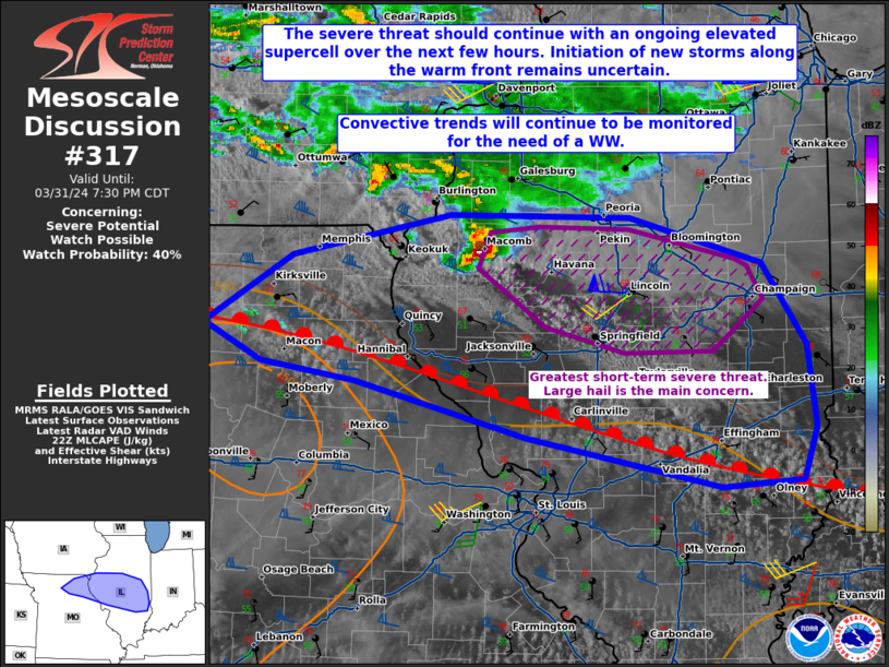
   Areas affected...portions of northern Missouri into central Illinois

   Concerning...Severe potential...Watch possible

   Valid 312226Z - 010030Z

   Probability of Watch Issuance...40 percent

   SUMMARY...Severe hail will accompany ongoing elevated supercell in
   west-central IL, moving into central IL, in the near term.
   Convective initiation is more uncertain farther south along the warm
   front in northern MO given weak forcing. Buoyancy and shear does
   favor severe storm development should convective initiation occur.
   Convective trends are being monitored for the need of a WW issuance.

   DISCUSSION...An elevated supercell in west-central IL, with a
   history of marginally severe hail, persists within strong zonal
   mid-level flow to the north of a warm front. Strong 850-700 mb WAA
   continues to advect adequate moisture ahead of the supercell in
   central IL, boosting MUCAPE into the 500-1000 J/kg range (per 21Z
   mesoanalysis). Meanwhile the stronger southwesterly WAA beneath 60+
   kt westerly 500 mb flow is contributing to modestly curved but
   elongated hodographs. As such, severe hail development may persist
   with this supercell for a couple more hours.

   Meanwhile, surface-based convective initiation from agitated CU
   farther south along the warm front, draped from roughly Linn County
   MO to Jasper County IL, remains uncertain in the absence of strong
   forcing. Surface heating has boosted MLCAPE into the 1000-1500 J/kg
   range amid stronger deep-layer shear (i.e. elongated and curved
   hodographs supporting 60+ kts of effective bulk shear). As such, any
   storms that can initiate and become sustained may produce severe
   hail/wind. Convective trends will continue to be monitored for the
   possibility of convective initiation over the next few hours.

   ..Squitieri/Guyer.. 03/31/2024

   ...Please see www.spc.noaa.gov for graphic product...

   ATTN...WFO...LOT...ILX...LSX...DVN...EAX...

   LAT...LON   39919320 40399240 40689096 40678934 40358816 39788775
               39208768 38848780 38788853 39149028 39539183 39669268
               39919320
|
|
Top/All Mesoscale Discussions/Forecast Products/Home
|
|


