|
| Mesoscale Discussion 318 |
|
< Previous MD Next MD >
|
|
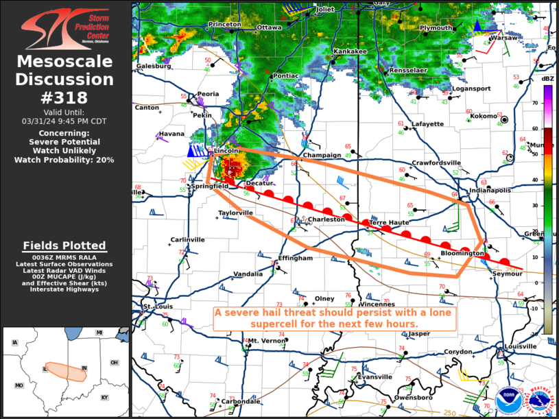
   Mesoscale Discussion 0318
   NWS Storm Prediction Center Norman OK
   0738 PM CDT Sun Mar 31 2024

   Areas affected...portions of central Illinois into western Indiana

   Concerning...Severe potential...Watch unlikely

   Valid 010038Z - 010245Z

   Probability of Watch Issuance...20 percent

   SUMMARY...A long-lived supercell may persist for at least a few more
   hours across central and eastern IL into western IN with severe
   hail. The severe weather threat is expected to remain localized
   through evening.

   DISCUSSION...A long-lived supercell continues to traverse a diffuse
   warm-front over central IL, where upper 60s/mid 50s F surface
   temperatures/dewpoints are boosting MLCAPE/MUCAPE to 500 J/kg (per
   00Z mesoanalysis). Though CAPE profiles are thin (based on the
   latest RAP forecast soundings and the 00Z observed ILX sounding),
   modestly curved low-level hodographs with mid/upper-level elongation
   suggest that vertical wind shear remains strong (i.e. 60+ kts of
   effective bulk shear). While the supercell will likely remain
   outflow dominant, efficient severe hail production should continue
   for at least a few more hours across central IL into western IN
   before the low-level jet veers, reducing convergence along the front
   and potentially supporting weakening convective potential later this
   evening. In the meantime, the severe threat may be constrained to
   this lone supercell. Convective trends will continue to be monitored
   for the need of a WW issuance, but current thinking is that the
   severe threat should remain localized over central IL/IN this
   evening.

   ..Squitieri/Guyer.. 04/01/2024

   ...Please see www.spc.noaa.gov for graphic product...

   ATTN...WFO...IND...ILX...

   LAT...LON   39588894 39878942 40138937 40228902 40108806 39808662
               39678615 39308599 38978631 39018688 39268815 39588894
|
|
Top/All Mesoscale Discussions/Forecast Products/Home
|
|


 @NWSSPC