|
| Mesoscale Discussion 319 |
|
< Previous MD Next MD >
|
|
Mesoscale Discussion 0319
NWS Storm Prediction Center Norman OK
1235 PM CDT Mon Apr 01 2024
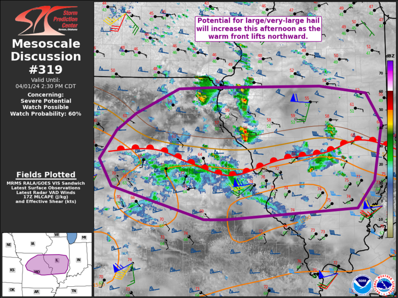
Areas affected...Portions of northern Missouri into central Illinois
Concerning...Severe potential...Watch possible
Valid 011735Z - 011930Z
Probability of Watch Issuance...60 percent
SUMMARY...An increase in storm coverage is expected along/north of a
warm front this afternoon. Large to very large hail will be the
initial threat. A greater tornado threat can be expected late
afternoon/early evening with discrete storms near the boundary.On or
more watches are possible this afternoon, but timing is not certain.
DISCUSSION...The 12Z observed ILX sounding showed moderately steep
mid-level lapse rates. As the warm front has lifted northward within
the mid-Mississippi Valley, substantial low-level moistening has
occurred in parts of central Illinois. With time, this boundary is
expected to continue to lift northward. Initial weak, elevated
convection has developed in northern Missouri and central Illinois.
This activity should remain sub-severe in the short term. As
destabilization continues into the afternoon, some of these storms
may become surface based. Given the wind profiles and lapse rates,
large hail would be possible. Very-large (2+ in.) hail could occur
with the stronger supercells. Storms north of the warm front will
remain elevated. Some increase in coverage and intensity appears
possible as theta-e advection aloft increases as the 850 mb low
deepens.
There remains some uncertainty as to the exact timing of an increase
in storm coverage. Several CAMs suggest coverage increases later in
the afternoon as the upper trough moves farther east. The tornado
threat will at least initially be low. However, low-level shear will
increase late this afternoon/early evening. Storms ongoing near the
warm front will consequently have a greater tornado potential at
that time.
On or more watches are possible this afternoon, but timing is not
certain.
..Wendt/Thompson.. 04/01/2024
...Please see www.spc.noaa.gov for graphic product...
ATTN...WFO...PAH...ILX...LSX...DVN...SGF...EAX...
LAT...LON 39109422 39629384 39939340 40399240 40429164 40438910
40298802 39758767 38728788 38228828 38039132 38049180
38619391 39109422
|
|
Top/All Mesoscale Discussions/Forecast Products/Home
|
|


 @NWSSPC