|
| Mesoscale Discussion 320 |
|
< Previous MD Next MD >
|
|
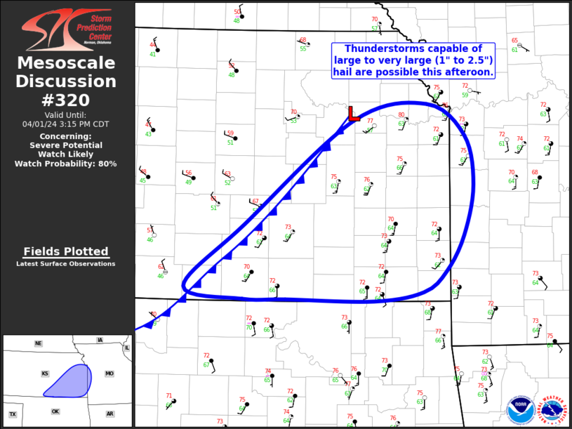
   Mesoscale Discussion 0320
   NWS Storm Prediction Center Norman OK
   0113 PM CDT Mon Apr 01 2024

   Areas affected...Central/Eastern KS

   Concerning...Severe potential...Watch likely

   Valid 011813Z - 012015Z

   Probability of Watch Issuance...80 percent

   SUMMARY...Thunderstorms capable of large to very large (1" to 2.5")
   hail are possible across central and eastern KS this afternoon. A
   strong gust or two is also possible.

   DISCUSSION...Recent surface analysis places a low over northeast KS
   with a cold front extending southwestward from this low through
   south-central KS. Low-level stability remains within much of the
   region ahead of this front, where the surface conditions are
   characterized by temperatures in the low/mid 70s and dewpoints in
   the low 60s amid widespread cloud cover. Even so, steep mid-level
   lapse rates are in place and the combination of broad warm-air
   advection and ascent along the front is expected to result in
   convective initiation within the next hour or two.

   Given the initially elevated and embedded storm character, a
   somewhat messy storm mode is anticipated once initiation occurs.
   Even so, deep-layer vertical shear is quite strong, with recent
   mesoanalysis estimated 60 to 70 kt of 0-6 bulk shear. This shear is
   sufficient for updraft organization within in mature, deep updrafts.
   The presence of steep lapse rates will favor the development of
   large to very large hail (i.e. 1" to 2.5") within these mature and
   organized storms. Given the low-level stability and weak low-level
   shear, the tornado potential for the next few hours should remain
   low. However, further air mass destabilization and strengthening
   low-level flow over time may allow these storms to trend more
   surface based as they move eastward/northeast into MO, resulting in
   an increase tornado threat.

   ..Mosier/Thompson.. 04/01/2024

   ...Please see www.spc.noaa.gov for graphic product...

   ATTN...WFO...SGF...EAX...TOP...ICT...

   LAT...LON   37849748 39019596 39189492 38849439 38289427 37739441
               37339466 37109498 36999567 37019691 37029750 37149833
               37849748
|
|
Top/All Mesoscale Discussions/Forecast Products/Home
|
|


 @NWSSPC